


Oct 7

Turkey and its surrounding areas have been handed over to various peoples throughout history, each carrying a diverse legacy. Whether of different nationalities or common origins, the region's inhabitants have left behind a variety of cultural structures, artifacts, and stories that have left their mark on the future. Therefore, we have prepared a guide that encompasses them all. Welcome to Anatolian history, chronologically.
In the heart of southeastern Turkey lies a site that is quietly rewriting the story of human civilization: Göbekli Tepe . Often described as one of the world's oldest known temples, this monument is much more than a pile of stones.
We'll uncover the cultural and historical significance of Göbekli Tepe and explore how it offers rare, eye-opening insights into the earliest stages of human society. From its enigmatic carvings to the questions it raises about who we are and how we live, Göbekli Tepe invites us to rethink what we know about the roots of civilization.
Nestled among the rolling hills near Şanlıurfa in southeastern Turkey, Göbekli Tepe is a mysterious site that quietly questions our understanding of human history. It may appear to be a pile of ancient stones, but in reality, it is a massive archaeological site that predates Stonehenge by 6,000 years. Built around 9600 BC, Göbekli Tepe holds the title of the oldest monumental structure yet discovered.
What makes this even more mind-boggling is that this settlement wasn't built by farmers or settled communities . It's intriguing that such a large and symbolically rich structure was built by hunters and gatherers, something we never imagined possible. The massive T-shaped columns, some reaching 20 meters tall and weighing several tons, are notable for their intricate animal figures and symbols, and are among the earliest examples of storytelling in human history.
Archaeologists believe that Göbekli Tepe was not a settlement, but rather a center of worship—indeed, the world's first temple. This suggests that social cohesion may have predated agriculture. In other words, Göbekli Tepe suggests that the desire to gather and worship, rather than the temples built after humans adopted a settled lifestyle, may have been the primary reason for people to organize.
From a distance, Göbekli Tepe may appear as a structure composed of a few ancient stone fragments. But when you truly look closely, you realize that each carved animal figure, each rising column, is much more than mere ornamentation. These are not random carvings, but gateways to the world of people who lived 11,000 years ago.
So why did they go to such lengths to create this massive structure? Archaeologists and historians believe that this site was a religious gathering place for early humans, a sacred space where they connected with divine beings, nature, and their ancestors.
Many of the stone pillars are adorned with images of foxes, vultures, snakes, and other animals that may have held significant significance for some. These carvings demonstrate that the prehistoric world held sacred significance, almost like an open-air shrine. The people who built Göbekli Tepe were not simply striving for survival; they also sought to imbue their lives with profound meaning.
Perhaps what makes Göbekli Tepe so powerful is that it reminds us that our need for faith greater than ourselves, for coming together, for worship, and for creating, dates back to ancient times.
One of the things that truly surprises scholars is the implications it offers for why this site brought early humans together. Contrary to the traditional view that humans turned to religion after they began farming and establishing permanent settlements, Göbekli Tepe completely overturns this notion.
As highlighted in Popular Archaeology , the scale of the effort required to build Göbekli Tepe is immense. The massive stones, some weighing more than a chariot, were quarried and transported without the support of wheels or domesticated animals. The site was not built and abandoned; it was used, expanded, and eventually deliberately buried over time. This demonstrates the long-standing and growing significance of Göbekli Tepe over generations.
The people who lived here were nomadic communities. Yet, they came together to create a sacred and monumental structure. This event demonstrates that the need for people to gather, share their beliefs, and create symbols of belonging preceded the need for sedentary life and food production. In fact, some archaeologists argue that the desire to gather for shared worship led to the emergence of agriculture. Spirituality and symbolism, rather than the comforts offered by settled life, emerge as the fundamental building blocks that laid the foundations of civilization.
This site, recognized as a UNESCO World Heritage Site, continues to be considered one of the most significant archaeological discoveries of our time. According to researchers at the German Archaeological Institute, this site represents a major leap forward in human cognitive and social abilities. Moreover, it is suggested that this leap may have occurred even before the agricultural revolution. These findings demonstrate that the current narrative of human history is changing.
The site's rediscovery is reshaping not only archaeology but also the way we talk about cultural identity and humankind. Tepe Telegrams reveals how Göbekli Tepe stands as "humanity's shared heritage." It is a unique site, not because of group affiliation, but because it reflects a moment when people first came together around shared beliefs and collective goals.
The current debate surrounding Göbekli Tepe, reported in The Guardian, raises a much broader, philosophical question: What does it mean to be human? These carefully placed, deeply meaningful stone structures reveal that civilisation is not an accidental byproduct, but rather that storytelling and art are fundamental elements that bring humanity into being.
Göbekli Tepe holds a place in history as a reminder that our identity and our past are far more deeply rooted than we think. It's not just a site studied by archaeologists; it also serves as a mirror through which we can all reflect. Whether you walk among the stone pillars or read its story from the other side of the world, Göbekli Tepe challenges us to confront the most profound questions: Why do we build? What is the power that binds us together? And what will we leave behind?
Have you ever wondered what life was like in one of the world's first cities? We're journeying back in time to explore Çatalhöyük , a historic site that offers a rare glimpse into how early humans lived, how they formed communities, and how they made sense of their world. From its surprising discovery to its incredible archaeological treasures, we'll reveal what daily life was like for the people who called it home. Let's take a look at ancient mysteries, unique structures, and how civilization as we know it may have begun.
Let's begin our journey with a brief archaeological excursion. Çatalhöyük, one of the world's most striking Neolithic sites, was first discovered by British archaeologist James Mellaart in 1958. Located in southern Anatolia, near the modern-day city of Konya in Turkey, the site has become a treasure trove of information for understanding how human settlements functioned thousands of years ago.
When Mellaart first encountered the site, no one expected it to be such a major event. But once excavations began, ancient houses, murals, tools, and even temples began to emerge layer by layer. It quickly became clear that this was no ordinary village, but a window into the past, dating back to 7100 BC.
What is particularly memorable about Çatalhöyük is its sheer size and its vast history. It was home to thousands of people, a tightly knit, beehive-like urban structure. And most strikingly, it lacked streets. People walked on rooftops and entered their homes through openings in the ceilings.
So when we ask, “Where and when was Çatalhöyük discovered?” the answer is more than just a place on a map or a date in a book. It’s the beginning of an ongoing journey into how our ancestors lived, thought, and shaped their world long before modern cities existed.
After the discovery of Çatalhöyük, it didn't take long for the site to capture the attention of the international archaeological community. However, things really took off in the 1990s, under the leadership of Ian Hodder of Stanford University. The incorporation of new technologies into excavations allowed researchers not only to excavate the earth but also to reach deeper layers of human life, both literally and figuratively.
As the crews slowly removed the brick walls and floors, they discovered an unexpected story. What they found wasn't just a settlement; it was a deeply connected society, filled with art, religious rituals, and a unique sense of community. People were buried beneath their homes, murals adorned the stones, and symbolic objects were meticulously placed, as if telling a story no one had yet written. It was as if each layer of soil revealed not only artifacts but also thoughts, beliefs, and ways of life.
One of the most exciting things about these excavations is that news continues to come in. New methods in DNA analysis, soil chemistry, and digital reconstruction are constantly reshaping what we know. The story of Çatalhöyük is not stuck in time; on the contrary, with each new discovery, it continues to reveal how the world's first communities thought and lived.
The houses here weren't just places to eat and sleep; they were carefully crafted spaces reflecting social structure, family order, and even spiritual values. As mentioned earlier, the houses at Çatalhöyük were built right next to each other, with no streets between them. In this environment, where people moved, the roofs formed a dense, interconnected structure. There were no doors at ground level. Instead, residents climbed wooden ladders and entered their homes through holes in the roof.
Inside, each house had a fairly standard layout. There was a large central room where most of daily life took place. Activities such as cooking, sleeping, working, and even worship took place here. Raised platforms were often located along the walls, used for sleeping or storing belongings. The hearth or oven, a warm and important part of daily life, was usually located in a corner. These were not only practical spaces but also deeply meaningful spaces. People buried their remains near the floor of their homes, uniting life and death in a common space.
The inhabitants of Çatalhöyük paid as much attention to detail as to the layout of their homes. Walls were plastered and often repainted repeatedly. Some houses even had murals and reliefs. A 2005 excavation report highlights how building materials such as adobe, plaster, and timber were reused and carefully recycled. This demonstrates that people had a strong understanding of construction and sustainability long before modern terms like "environmentally friendly" existed.
Now that we've taken a look inside the houses at Çatalhöyük, it's time to explain what life was really like for the people who lived there.
The people of Çatalhöyük had a diverse diet, including grains such as wheat and barley, as well as peas, lentils, nuts, fruit, and abundant wild game and domesticated animals. According to research published in American Antiquity, meals were more than just food; they were highly social and symbolic acts. Families cooked and ate together in the same spaces where they slept and worked. Beyond a basic need, food became a unifying element of the community.
Cooking was often done in ovens built into the floors of their homes, and researchers have found charred remains of bread, seeds, and even bones. The fact that these people also consumed seafood and birds is striking, demonstrating the extent to which they took advantage of nature's resources.
So what exactly were these people wearing while doing all this? Textile remains from Çatalhöyük reveal that people made clothing from the bast fibers, the inner bark of trees like oak and willow. According to Turkishtextile, these early weavers spun the tree fibers into yarn, creating surprisingly soft and breathable fabrics. This demonstrates not only their innovators but also their distinct sense of comfort and style.
Daily life also included handicrafts, religious practices, and collaboration. There is evidence of dye-making, obsidian toolmaking, and wall paintings. The Çatalhöyük Research Project describes this as a strong sense of community, where houses were not only lived in but sometimes shared by multiple generations. Despite its historical depth, Çatalhöyük was a living space that was captivating with its vitality, social ties, and human touch.
The Neolithic settlement of Çatalhöyük, located in Konya, is notable for hosting pioneering projects in digital archaeology. One of these, the "3D-Digging at Çatalhöyük" project, initiated a significant transformation in archaeological methodology by integrating advanced digital documentation into the excavation process in 2009-2010. The project's primary goal was to enable retrospective analysis of the excavation process and to structure the resulting data so that it could be reproduced in virtual environments.
In this context, the East Mound excavation site was documented at the macro scale with laser scanners, while specific architectural elements, such as Building B89, were recorded at the micro scale using high-resolution photogrammetric methods. The mass graves and architectural structures uncovered during the excavations were photographed in detail and converted into digital 3D models. All resulting models were integrated into geographic information systems and incorporated into both analysis and archiving processes.
Nestled among the impressive landscapes of Central Anatolia, the Phrygian Valley offers a window into the cultural and spiritual world of the ancient Phrygian civilization . We aim to explore, with you, the readers, the monumental rock tombs meticulously carved into the volcanic tuff rocks, silent witnesses to this civilization, which flourished between the 8th and 6th centuries BC.
By observing examples of Phrygian tombs, symbolic motifs, and the geographic locations of sacred sites, we will examine how the Phrygians reflected their cosmology and culture in stone. We also focus on how these archaeological remains offer a broader perspective on Anatolia 's cultural heritage and the continuity of ancient funerary rituals.
The Phrygian civilization once flourished in the heart of Anatolia, leaving behind a rich cultural heritage, a world of beliefs, and monumental structures. Gaining power around their capital, Gordion, the Phrygians emerged on the historical stage in the 8th century BC and are best known for their legendary ruler, King Midas . Their influence spread across the vast landscape of Central Anatolia, where they carved sacred and civic spaces directly into the volcanic rocks.
The Phrygian Valley bears the most striking traces of this civilization, with its landscape dotted with natural rock formations, monumental tombs, and religious shrines. Among these structures, Yazılıkaya (also known as Midas City ), with its intricately carved facades and sacred architecture, stands out in particular.
The Yazılıkaya excavations, which resumed in 2023 after a 71-year hiatus, have unearthed significant new information about Phrygian architectural techniques and traditions. Archaeologists have unearthed altars and worship areas thought to have been used in ancient ceremonies, further emphasizing the spiritual significance of this sacred site.
A discovery made at Gordion in June 2025 has added a new dimension to Phrygian burial customs. A royal tomb, thought to date back to the 8th century BC, is thought to have belonged to a member of the royal family, possibly related to King Midas himself. The structure's wooden elements, preserved for approximately 2,800 years, provide invaluable insights into Phrygian funerary practices, craftsmanship, and social hierarchy.
As we move deeper into the Phrygian landscape, the visual impact of the tomb architecture becomes more pronounced. These rock-cut tombs, meticulously carved into the volcanic rock, stand as enduring symbols of the civilization's values and beliefs. They are not only marvels of engineering, but have gone down in history as meticulously crafted narratives in stone. Each facade tells a silent story about the identity of the deceased and the worldview of the society that created them.
Many tombs have temple-like facades, with gabled roofs and false doors carved into the flat, vertical surfaces. These architectural details are not merely decorative; they also symbolize divine concepts such as transition, protection, and divine presence. Stepped motifs, indented panels, and symmetrical arrangements reflect religious symbolism, marking the tombs as a liminal space between the worlds of the living and the dead.
Studies of tombs found in the mountainous regions of Phrygia during the Hellenistic and Roman periods reveal how the Phrygians retained their unique aesthetic sense while incorporating external influences. Monumental facades generally consisted of three parts: a solid base, a central section decorated with ornate patterns, and a gable roof above. These structural elements present a formal and dignified appearance, underscoring the importance of the occupants. The recurring pattern of geometric ornamentation demonstrates both the continuity of an artistic tradition and carries symbolic meanings that point to the universal order (the sublime).
Beyond their architectural forms and symbolic ornamentation, Phrygian tombs also reveal how the ancient Phrygians viewed themselves and how they wished to be remembered. In particular, many rock-cut monuments from late Phrygia feature visual representations, with figures rendered in low relief on the tomb facades. These images add a human touch to the geometric and monumental structure of the tomb architecture.
The figures are generally depicted facing forward, sometimes seated, or holding ritual objects (e.g., drinking glasses). These postures are thought to be symbolic, not decorative, but rather express identity, prestige, and continuity. Indeed, the Phrygians used art and relief carving as representational tools, transforming their tombs into visual narratives of who they were in life.
Moreover, these works are not unique to the Phrygians. Similar motifs also appear in other Anatolian cultures, such as the Lydians and Lycians. These commonalities point to similar understandings of social culture and beliefs about the afterlife. Therefore, it is fair to say that for the Phrygians, funerary art was part of a comprehensive cultural structure that reflected an individual's identity in both the physical and spiritual realms.
The Phrygian legacy continues to endure today in academic research and global cultural heritage conservation efforts. With the recognition of this unique cultural value, the Phrygian Highlands, commonly referred to as "Mountainous Phrygia," have been officially inscribed on the UNESCO World Heritage Tentative List. This list encompasses a vast network of rock tombs, open-air sanctuaries, settlement remains, inscriptions, and pathways spread across the provinces of Eskişehir, Afyonkarahisar, and Kütahya in Central Anatolia.
According to UNESCO, what distinguishes the Phrygian Valley is its profound interweaving of nature and culture. The geological structures, composed of soft volcanic rock, not only provided a physical backdrop for the Phrygians but also profoundly influenced their ways of building, worshipping, and burying their dead.
Preserving this heritage remains a challenging and ongoing challenge. As threats such as agricultural activities and environmental degradation persist, sustainable tourism and site preservation efforts at both the local and national levels are becoming more crucial than ever. Projects such as the " Phrygian Way, " a long-distance hiking route connecting ancient sites, are being implemented to encourage interaction, engage local communities, and raise awareness while respecting the region's historical fabric.
Therefore, the Phrygian Valley is more than just a relic of the past; it is a living cultural heritage. Its tombs and carvings remind us how ancient peoples reflected their identities, while also inviting us to reflect on how we value and preserve the cultural legacy we leave behind today.
When most people think of Cappadocia , they imagine extraordinary landscapes, colorful hot air balloons floating over fairy chimneys, and enchanting caves carved into the rock. While all of this is truly magical, there's another often-overlooked aspect of Cappadocia: the underground cities lurking beneath the surface. These ancient cities , carved deep underground, tell stories of survival, faith, and incredible human ingenuity. As we journey into the depths of these subterranean wonders, we'll uncover their historical significance and the impressive reason they were built in the first place.
Before hot air balloons and cave hotels, Cappadocia's history was home to something far more fascinating: a hidden world beneath the earth. These subterranean cities, some extending as deep as 60 meters and consisting of multiple levels, are believed to have emerged thousands of years ago. While many historians date their origins back to the Hittites around 1200 BC, it was the Christians who first truly popularized them. During periods of religious persecution, especially during the Roman Empire, entire communities fled underground to seek safety. These subterranean cities weren't just temporary shelters; they were also fully functional cities carved into the soft volcanic rock, complete with living quarters, kitchens, storage facilities, wells, wineries, and even churches.
One of the most incredible things about these underground cities is their incredible feats of engineering. These cities could house thousands of people for months at a time, a testament to the seriousness of the threat from above. Imagine families living for generations without sunlight, raising children, worshipping, and living in near-secrecy. Isn't that both unforgettable and awe-inspiring? What makes this story even more compelling is how these cities were rediscovered. Some were discovered by chance in the 1960s when a homeowner demolished a basement wall, revealing a vast network of tunnels.
At first glance, the idea of living underground might sound a bit strange, even terrifying to our claustrophobic readers. However, for the ancient people of Cappadocia, it was the only way to escape a dangerous world. This region had suffered its share of invasions, raids, and the misuse of religion over the centuries. So, instead of constantly fleeing or fighting, the locals found a more ingenious solution: they built entire cities beneath their feet. These underground shelters provided shelter not just for days but for months, keeping entire communities safe and protected from harm.
The people of Cappadocia didn't just dig a few tunnels and hope for the best; they designed full-scale cities with remarkable details. I challenge you to close your eyes and imagine: stables for animals, kitchens with clever chimney systems to ventilate smoke, warehouses filled with food, deep wells for fresh water, and even specially designed spaces for prayer and education. Families lived, worked, cooked, and lived underground, creating a vibrant life behind the scenes.
Despite the darkness and isolation, these subterranean homes maintained a sense of order and community. They weren't spectacular, of course, but they were safe, efficient, and impressively advanced for their time. Today, wandering through these ancient tunnels, one cannot help but marvel at the resourcefulness of the people who carved their lives entirely underground, transforming hardship into innovation and fear into resilience.
These vast underground complexes, carved into the soft volcanic rock, weren't built overnight. Generations of humans painstakingly expanded them over the centuries, creating multi-level structures complete with air shafts, ventilation systems, water wells, communal kitchens, and even defensive rolling stone gates. What's truly breathtaking is how these ancient architects, without the use of any modern tools, managed to maintain constant temperatures, ensure clean air, and design entire cities capable of sheltering thousands in times of danger.
But technical achievements are only part of the story. Beneath all this architectural planning lies a world of legends and unanswered questions. Some locals believe these tunnels are not only sanctuaries but also sacred spaces, possibly even linked to celestial alignments. Others circulate tales of secret knowledge, still-undiscovered secret passages, or connections to civilizations far older than what written records reveal. Modern pop culture has also contributed to these stories with theories about aliens, subterranean energy fields, and forgotten technologies. While these wild claims have little scientific basis, they undoubtedly add an extra layer of beauty to the already captivating experience of walking through the silent, dark corridors.
So, what makes the underground cities of Cappadocia so special? Frankly, everything. It's not just the jaw-dropping subterranean architecture or the fact that humans have managed to carve entire cities by hand deep underground. These cities are an incredible fusion of human perseverance, creativity, and mystery, hidden in every tunnel and stone. They were born of necessity, built as safe havens from invaders, oppression, and war. But over time, these spaces became more than just shelters. People built their lives here, cooked their meals, and lived quietly with their families.
What makes them unforgettable is their continued ability to capture our imagination. Add to this their engineering, the legends—stories of secret passages, sacred rituals, even wild theories about aliens—and the resulting mystery takes on a whole new dimension. Whether you're a history lover, an architecture enthusiast, or simply someone seeking adventure, the underground cities of Cappadocia open the doors to a timeless world.
Troy , or Troy , is one of the most iconic cities of ancient myth, described in Homer 's Iliad as the site of a great battle between the Greeks and Trojans. For centuries, many believed this story to be entirely fictional. However, the idea that Troy might have a real, historical basis began to gain serious traction in the 19th century, thanks to a combination of ambitious discoveries and newly developed archaeological techniques.
We examine the process of Troy's discovery and aim to follow in the footsteps of archaeologists, particularly Heinrich Schliemann , the controversial figure who claimed to have discovered the ancient city in modern-day Turkey. We will examine how legends and historical evidence intersect, and how the boundaries between myth and reality are often blurrier than we think.
The ancient city of Troy holds a central place in Greek mythology and was immortalized in Homer's Iliad . This epic tells the story of the legendary Trojan War between the Greeks and Trojans, which began with the abduction of Helen by the Trojan prince Paris. The Iliad is not only a tale of war and heroism; it also delves deeply into universal themes such as honor, mortality, and the meaning of being human.
In Greek culture, heroes were often viewed as revered figures possessing extraordinary abilities and believed to be descended from the gods. Achilles , the protagonist of the Iliad , is one of the most striking examples of this concept. Son of the sea goddess Thetis and the mortal Peleus, Achilles embodies both divine power and human fragility. While virtually invincible, his mortality is a poignant reminder of the inevitable fate shared by all humans.
The Iliad emphasizes the fleeting nature of life and glory. Achilles' internal struggle between a long, uneventful life and a short, glorious one underscores the Greek ideal of kleos, the eternal fame achieved through heroic deeds. This pursuit of honor, even at the cost of life, constitutes a cornerstone of ancient Greek values.
In the epic, the gods are depicted as active beings who directly intervene in human affairs. They frequently intervene in wars and influence their course. This close interaction between the divine and mortal worlds demonstrates the Greeks' belief that the gods are omnipresent and have a direct influence on human destiny.
While the historicity of the Trojan War remains a matter of scholarly debate, Troy's cultural and literary significance is undeniable. The legends surrounding the city have inspired countless works of art, literature, and philosophy, cementing its place in the collective imagination of Western civilization.
While the Iliad paints a vivid picture of the Trojan War, for centuries many scholars considered Troy a legendary city. This perception began to change in the 19th century when Heinrich Schliemann, a German businessman and archaeology enthusiast, embarked on a quest to find the legendary city.
Schliemann focused his excavations on the Hisarlık mound in northwestern Turkey. These excavations unearthed numerous archaeological layers indicating that the area had been inhabited for thousands of years. Among these layers, Schliemann discovered the ruins of Troy, which he believed included city walls and artifacts he associated with Homer's epics.
Later archaeological studies supported the idea that Hisarlık was indeed the site of ancient Troy. Artifacts unearthed during excavations, ranging from pottery and weapons to the remains of city walls, demonstrate that this city, with its complex history, underwent phases of destruction and reconstruction that coincided with the timeline of the so-called Trojan War. These remains offer concrete connections to the epic narrative.
While the historical veracity of Homer's narrative remains a matter of debate, the archaeological findings at Hisarlık have significantly bridged the gap between legend and history. This region truly demonstrates the enduring nature of ancient narratives and their roots in real events and places.
Following the initial discoveries at Hisarlık, Heinrich Schliemann began extensive excavations in the 1870s, believing he had found the legendary city of Troy. However, his methods were unconventional and often destructive. Eager to reach the layer he believed belonged to Homer, Schliemann dug a massive trench through the mound, inadvertently destroying the upper layers, which contained invaluable historical information.
The term "layer" we're talking about refers to the soil layers found in archaeological excavations that contain traces of settlement in a region from different periods. Each layer contains structures, artifacts, and traces of life from a specific time period. Excavations at the Hisarlık mound have identified nine main Troy layers (Troy I to Troy IX) and their subdivisions. These layers have revealed that Troy was destroyed and rebuilt numerous times throughout history.
In 1873, Schliemann unearthed a collection of gold and valuables, which he named " Priam's Treasure ," after the Trojan king mentioned in the Iliad . However, subsequent scientific analysis showed that this treasure dated back to approximately 2400 BC, much earlier than the accepted era of the Trojan War, the Troy II period.
Modern archaeological excavations using modern technology have unearthed numerous layers from different periods of settlement. Troy VI and VIIa, in particular, dating between 1700 and 1200 BC, are considered among the strongest candidates for the legendary city of Troy described in the Iliad . While Troy VI is notable for its imposing walls and well-organized urban planning, Troy VIIa is notable for its traces of destruction, likely the result of war.
Despite the controversy surrounding Schliemann's techniques, his work rekindled interest in the historical basis of ancient myths and laid the groundwork for future archaeological work at Troy. His findings, while marred by some methodological flaws, opened a new chapter in the study of the past world.
For years, archaeologists have been trying to determine the extent to which the narratives in the Iliad are based on historical fact and the extent to which they are merely myth. While excavations at Hisarlık, thought to be ancient Troy, have yielded scientific findings from a long and complex history, directly connecting these layers to the Trojan War in the Iliad remains a major challenge.
Despite these uncertainties, Troy's legacy remains powerful. The region continues to attract the attention of historians and tourists alike. Its story bridges ancient myth and historical research. Rather than proving every detail of Homer's epic, Troy invites us to explore how literature and concrete evidence shape our understanding of the past.
Archaeologists no longer seek to "prove" the Iliad , but instead aim to understand the experiences of the people who lived in Troy for millennia. Thanks to this approach, the legend of Troy remains not only a heroic tale but also a symbol of how myth and history can coexist in the archaeological record.
Some places in the world don't just tell stories of the past; they become stories themselves. The Ancient City of Ephesus is one of them. It still speaks to us not with words, but with its marble paths, its columns reaching to the sky, and the silent remains of marketplaces once teeming with life. It is a unique ancient city where the past feels so close it's practically tangible, where history awaits discovery around every corner.
Delve into the fascinating world of Ephesus, once a major center of culture, trade, and religion, exploring its prominence in ancient times, its connections to major empires, and the legacy it left behind. You'll also discover architectural marvels that still captivate visitors today, such as the stunning Library of Celsus and the massive Great Theatre, which once echoed with voices from centuries past.
But Ephesus is more than just rocks and ruins. It is a mirror of time, whispering how people lived, what they believed, and what kind of communities they formed thousands of years ago.
Located in western Türkiye, near the modern town of Selçuk, Ephesus stands as a testament to the rich tapestry of ancient civilizations. Once the most important Greek city in Asia Minor, Ephesus witnessed the rise and fall of empires, leaving behind a legacy etched in stone.
The history of Ephesus dates back to the mid-7th century BC. It survived Cimmerian attacks and later flourished under the rule of King Croesus of Lydia. During his reign, the Temple of Artemis, a structure so magnificent that it is considered one of the Seven Wonders of the Ancient World , was built.
The city came under Persian control in 546 BC and was liberated by Alexander the Great in 333 BC. Under Roman rule, beginning in 133 BC, Ephesus enjoyed a golden age and became the capital of the Roman province of Anatolia. The city's strategic location and impressive architecture, including the Library of Celsus and the Great Theatre, underscore its immense importance.
Today, the ruins of Ephesus invite visitors who wish to follow their footsteps on a journey through time, along the stone streets where philosophers, merchants and saints once walked.
As our journey through Ephesus continues, the city's architectural wonders unfold one by one. Each structure, with its cultural richness and artistic splendor, tells its own story.

Standing in the heart of Ephesus, the Library of Celsus is much more than a mere repository of scrolls; it's a tribute to the Roman senator Tiberius Julius Celsus Polemaeanus, built by his son in the 2nd century AD. Its ornate Corinthian columns and façade, adorned with statues symbolizing wisdom and knowledge, reflect Roman architecture's penchant for symmetry. Inside, the library, once home to thousands of scrolls, is one of the most important libraries in the ancient world. Beneath the library lies the sarcophagus of Celsus, who engraved knowledge and memory in stone.
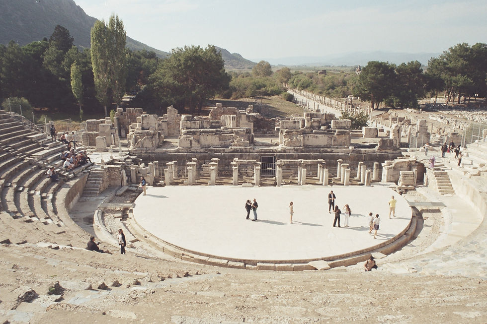
Descending from the city's hills, the Great Theatre emerges, carved into the slopes of Mount Pion. With seating for approximately 25,000, this amphitheater was the epicenter of entertainment, politics, and social gatherings. Its semi-circular design, typical of Roman theaters, provided ideal aural comfort, allowing sounds to reach every audience. Once adorned with elaborate columns and statues, the stage served as a stage for dramas, concerts, and public debates, reflecting the vibrant civic life of Ephesus.
Although only fragments remain today, the Temple of Artemis was once a testament to architectural perfection and religious devotion. Considered one of the Seven Wonders of the Ancient World, it was dedicated to Artemis, the goddess of hunting and fertility. Its immense size and stunningly beautiful reliefs attracted foreigners from far and wide, making Ephesus a center of religious worship in ancient times. The temple's design influenced countless subsequent structures and cemented its legacy in architectural history.
These structures, each bearing its own unique history, reveal Ephesus as a city where art, culture, and spirituality intertwined. Walking among these ruins, one cannot help but feel as if one is sharing the same breath with countless people whose voices, beliefs, and aspirations once filled one's heart.
Ephesus stood out not only for its structures but also as a spiritual center, echoing with the voices of people from all over the ancient world. At the heart of this spiritual life was the Temple of Artemis, both the city's symbol and its religious center. Dedicated to Artemis Ephesia, a unique interpretation of the Greek goddess, this temple served as a magnet for people seeking sanctification, divine guidance, and connection with the divine.
The temple's significance was not limited to its architectural splendor; it also served as a haven and safe haven, offering protection to those in need. The annual Artemis festival, known as Artemisia, attracted both devout believers and travelers, making Ephesus a vibrant center of religious fervor and cultural interaction.
Moreover, Ephesus played a key role in the early Christian era. The city is mentioned in the New Testament, where the Apostle Paul resided for a time, preached, and grappled with the challenges he faced while spreading Christianity in this city, steeped in pagan traditions. The transformation that took place in Ephesus, where paganism and Christianity coexisted for a time, is seen as a reflection of broader religious changes in the past world.
Visiting Ephesus is like stepping into a living museum. As you wander its streets, you can almost hear the bustling life that once filled the city and the echoes of its footsteps. The majesty of the Library of Celsus and the vastness of the Great Theatre are testaments to the city's former glory. These structures and others allow visitors to immerse themselves in the daily lives of the Ephesians, creating a tangible connection with the past.
To make the most of your visit, it's recommended to arrive early in the morning or late in the afternoon to avoid the crowds and the scorching midday sun. Comfortable shoes are essential for your comfort as the site spans a vast and rugged area. A tour with a knowledgeable local guide can enrich your experience by learning the historical context and facts behind the ruins. Alternatively, you can explore on your own, guided by the informative signs posted throughout the site, which is also quite common.
Don't forget to visit the nearby sacred and historical sites, such as the House of the Virgin Mary, believed to be the last sanctuary in Ephesus, and the Basilica of St. John, believed to house the tomb of St. John. These sites will help you understand the importance of Ephesus in the early Christian era.
In essence, a visit to Ephesus offers us a unique opportunity to walk through history, witnessing the remains of a civilization that shaped much of our modern world.
Ancient port cities, situated at the intersection of urban planning, trade networks, and engineering practices, provide valuable insights into these three areas. Among these, Ephesus and Patara stand out as two important centers along the Aegean and Mediterranean coasts, each with a distinct historical and architectural background. These cities were not merely centers of trade but also vibrant and dynamic urban spaces shaped by their strong connection to the sea.
By focusing on the structural characteristics of both cities' ports, the use of innovative technologies in maritime construction, and the broader influence of port design in antiquity, we aim to demonstrate how these coastal cities reflected both practical function and architectural vision, from the construction of breakwaters and canals to the integration of port facilities with civilian life.
We believe readers with a particular interest in maritime history or the past will find this comparison of Ephesus and Patara a compelling example of how modern technology shaped some of the ancient world's most influential port cities. So, if you're ready, let's take a look at how Ephesus and Patara have shaped history from past to present.
Ephesus, located on the Aegean coast of western Anatolia, was not always a coastal city. Over time, the city's relationship with the sea evolved due to geomorphological changes, particularly the gradual alluvialization of the Cayster River (now known as the Küçük Menderes). In previous discussions, we examined the city's temples and urban architecture, but here we focus specifically on its ancient harbor.
The Port of Ephesus , once directly connected to the Aegean Sea, played a crucial role in trade and cultural exchange, enabling the city to flourish as a commercial and political center during the Classical and Roman periods. The port's location, just south of the Temple of Artemis, was strategically chosen to take advantage of sheltered waters and proximity to land routes. However, sediment accumulation over the centuries eventually led to the port's decline, transforming Ephesus into an inland city far from the modern coastline.
Patara, by contrast, was naturally in a better position for maritime transportation. Located on the southwestern coast of Lycia, Patara boasted a deep, well-protected harbor formed by a combination of river sediments and coastal dunes. The region's natural geography made it a suitable port from the Bronze Age onward.
During the Roman period, it became an important maritime and business center, even serving as a base for the Roman provincial fleet. Patara's coastal geography not only provided advantages for defense and anchorage, but also enabled the city to develop as a hub for grain exports and communications between the eastern and western parts of the empire.
Both cities demonstrate how urban planning can directly impact economic function and long-term sustainability. While Ephesus struggled with environmental degradation and eventual isolation from the sea, Patara's more stable maritime position helped it maintain its role as a key port for longer.
Ephesus Port has been constantly struggling with sedimentation caused by the Cayster River. Recent geochemical and sedimentological studies indicate that port engineers have implemented adaptive measures to address this problem, such as dredging, channel widening, and the construction of artificial channels.
These efforts aimed to maintain the port's accessibility despite the gradual filling of the delta. A key aspect of the project was the long canal system that connected the inner harbor to the open sea, serving as a navigable corridor. Far from being merely a passive waterway, this canal was actively maintained and supported by retaining walls and drainage systems constructed with advanced hydraulic engineering know-how.
Patara Harbor , on the other hand, offered calm, deep, and sheltered anchorage thanks to the sand dunes and river delta surrounding the shore. Archaeological studies, including detailed architectural surveys, indicate that Patara's harbor infrastructure included quay walls, warehouses, and possibly ship sheds. This suggests that the harbor supported both commercial and military functions.
Patara's engineers also implemented environmental protection systems such as flood control tunnels and drainage channels. These systems helped prevent inland flooding during seasonal storms and maintained the port's year-round operation. The use of local stone, modular masonry, and precise orientation according to winds demonstrate that the structure was both meticulously designed and successfully adapted to the site's unique conditions.
Both ports exhibit a balance between functionality and technical mastery. Ephesus invested heavily in resisting environmental change through infrastructure, while Patara optimized its natural advantages through structural improvements. These engineering solutions not only sustained port operations for centuries but also demonstrated the broader capabilities of ancient societies to manage maritime challenges.
The harbor at Ephesus was not only an entry point for seafarers but also a gateway to the city's economic vitality. As research by the Center for Hellenic Studies has discussed, the processional route from the harbor to the Temple of Artemis and beyond was both symbolic and practical.
Merchants, travelers, and other visitors arriving by sea were guided into the heart of the city through a series of carefully planned public spaces. This alignment of the urban design with the port route reinforced the city's role as a cultural and religious center while facilitating the smooth movement of goods and people. The port area, with its large warehouses, commercial buildings, and proximity to the agora, reflected a high degree of economic integration.
Patara presents a parallel but different situation. According to historical and archaeological information obtained from Asia Minor, the harbor shaped the city's social and administrative structure. Liman Caddesi, a wide avenue paved with columns, directly connected the docks to civic structures such as the agora and theater. This multifaceted planning not only supported the efficient transportation of goods but also emphasized Patara's political and economic importance to the Lycian League.
Its harmony with its roads, marketplaces, religious and social spaces clearly reflects the urban planning decisions shaped around the port infrastructure. In this context, the sea was not merely an external boundary but also a guiding element of urban and economic life.
The ports of Ephesus and Patara continue to provide rich archaeological evidence that sheds light on ancient cities and maritime life.
At Ephesus, although the harbor was long submerged, excavations have revealed the remains of canals, quay walls, and storage facilities—traces of a once-thriving harbor that adapted to environmental change. These findings are helping scholars understand how urban centers managed coastal transformation over the centuries.
In Patara, the harbor is among the structures that have survived to the present day in excellent condition. Archaeologists have unearthed streets and structures leading to the harbor, as well as the foundations of the region's oldest lighthouse. This concrete evidence underscores Patara's importance for both maritime and trade.
Today, both sites are valuable not only for research but also as landmarks of cultural heritage. Their preservation demonstrates the enduring importance of port cities in economic relations and regional identity formation throughout the Mediterranean region.
Antalya is known not only for its beautiful beaches and modern resorts, but also for its deep-rooted connection to ancient history. The ruins of once-powerful civilizations that shaped the cultural and architectural fabric of the Mediterranean world are scattered throughout Antalya. Among these, the ancient cities of Perge , Aspendos , and Side hold special significance. These archaeological sites represent much more than mere ruins; they are living witnesses to centuries of human history, innovation, and cultural exchange.
With its grand avenues and magnificent city gates, Perge showcases the urbanism and elegance of the Roman period. Aspendos, home to one of the world's best-preserved Roman theaters, stands out for its architectural mastery and impressive acoustics, while Side, with its masterful blend of history and nature, boasts ancient temples, a vibrant agora, and a port that once served as a gateway to the Mediterranean's extensive trade networks.
The ancient city of Perge, located approximately 18 kilometers east of Antalya, is one of the most important archaeological sites in southern Türkiye. Originally founded by the Hittites and later influenced by Greek culture, Perge reached its peak during the Roman period, becoming a thriving center of trade, architecture, and civic life. Today, these ruins offer visitors a glimpse into the urban structure and daily life of a Roman metropolis.
One of Perge's most striking features is its remarkably well-preserved main street, lined with stone columns and adorned with ornate shops and the ruins of houses. A gate complex from the Roman Empire leads visitors to a vast agora, once the center of commerce and public life. The city's elaborate layout, along with its baths and the complex system of aqueducts running through the center of the main street, demonstrates the Romans' emphasis on hygiene, aesthetics, and engineering.
Perge also held religious significance. Known for its magnificent temple dedicated to Artemis, the city was a significant center for worshippers of the goddess. In later periods, with the spread of Christianity in the region, Perge also held a significant place in Christian history thanks to the visits of apostles such as St. Paul and St. Barnabas during their missionary journeys.
Another notable feature of the city is its Roman theater, which seats over 12,000 spectators. Nearby is a stadium once used for sporting events and public events. These monumental structures underscore Perge's role not only as a civic center but also as a cultural and entertainment center in the Roman world.
Continuing our journey to Antalya's other ancient heritage sites, we head to Aspendos, an archaeological wonder known for housing one of the world's best-preserved Roman theaters. Located near the town of Serik, Aspendos was founded by the ancient Greeks and later flourished under Roman rule. The city became a major cultural and economic center in the Pamphylia region, occupying a strategic position on important inland and coastal trade routes.
Aspendos's crowning jewel is undoubtedly its Roman theater, built during the reign of Emperor Marcus Aurelius in the 2nd century AD. Designed by architect Zenon , a native of the city, the theater holds an audience of approximately 12,000 to 15,000. Its unique features are its exceptional acoustics and robust structural integrity.
Unlike many other ancient theaters, Aspendos' stage building (scaenae frons) remains largely intact, allowing visitors to experience the theater as it would have been some 2,000 years ago. In fact, the theater is still used today for cultural festivals and performances, creating a bridge between the past and the present.
Beyond its theater, recent archaeological discoveries have added new depth to Aspendos's cultural landscape. Excavations in early 2025 unearthed a remarkably well-preserved statue of the Greek god Hermes, along with fragments of other deities such as Aphrodite, Eros, and Nemesis. These findings highlight not only the city's artistic richness but also its religious diversity during the Roman imperial period. The intact presence of the Hermes statue, in particular, reflects the high level of craftsmanship of the second century AD.
Notable features of Aspendos include its aqueduct system, one of the finest examples of Roman engineering in Anatolia, as well as the ruins of a basilica, agora, and stadium. Together, these structures reflect the city's multifaceted identity as a place of commerce, civic life, and spiritual devotion.
The city of Side offers a unique blend of historical charm and coastal beauty. Once a thriving port city of Pamphylia, Side rose to prominence as a commercial and cultural center during the Hellenistic and Roman periods. Its strategic location along the Mediterranean made it a vital hub, particularly for the olive oil, wine, and slave trade.
One of Side's most famous landmarks is the Temple of Athena , which recently underwent a major restoration and reopened to the public in 2024. Located near the harbor and boasting breathtaking sea views, the temple was dedicated to the goddess Athena, revered as the city's protector. The restored structure retains its Corinthian columns and coastal orientation, offering visitors a strong visual connection between religion, architecture, and maritime life in the ancient world. Illumination of the temple at night adds a new dimension to its appeal, transforming it into both a historical and aesthetic landmark.
Another notable highlight in Side is the Side Museum , housed in a former Roman bathhouse. Reopening to the public in early 2025 after undergoing renovations, the museum houses a large collection of inscriptions, statues, sarcophagi, and architectural fragments from local excavations. Of particular value are the Latin and Greek inscriptions, which offer insights into Side's civic life, legal systems, and public figures. The museum not only showcases artistic excellence but also serves as a textual archive of the region's past.
In addition to its temples and museum, Side boasts a large Roman theater, agora, aqueducts, and city walls surrounding the city's ancient fabric. What distinguishes Side is how these ancient structures coexist with modern life. The ruins are seamlessly integrated into the modern city, allowing visitors to wander between cafes and temples in minutes.
Perge, Aspendos, and Side form a trio that reveals the rich and multilayered heritage of ancient Anatolia. Each with its own unique identity, these cities—Perge, reflecting the Roman urban landscape, Aspendos, captivating visitors with its imposing theater, and Side, distinguished by its sacred sites on the seashore—are the living, breathing legacies of the civilizations that flourished along the Mediterranean coast.
From a cultural perspective, these sites reveal the complexity of ancient life in the region: religious devotion expressed through temples and inscriptions; public entertainment made possible by amphitheaters and stadiums; and urban planning that prioritized aesthetics and civic engagement. These elements demonstrate how communities valued not only survival but also art, order, and identity. The recent restoration of important monuments such as the Temple of Athena in Side heralds a growing awareness of the importance of preserving these heritage sites for future generations.
From an archaeological perspective, these cities are a treasure trove for researchers and historians. Ongoing excavations and the recent discovery of statues at Aspendos continue to reveal new findings that expand our understanding of ancient belief systems, social structures, and artistic techniques.
In essence, Perge, Aspendos, and Side have become much more than archaeological centers. They have earned their place in history as enduring symbols of human creativity and historical continuity. By preserving their structures, interpreting their stories, and sharing them with the world, we not only honor the past but also create the building blocks of a future built on a more solid cultural and historical foundation. These ancient cities remind us that the stones beneath our feet still whisper, if only we are willing to listen.
Ancient cities are historical sites that capture our imagination with their silence, standing tall for centuries, whispering countless stories about empires, faiths, trade, and everyday life. The ruins of Ani, also known as the "City of 1001 Churches," are one such city. We will witness Ani's fascinating journey, revealing its transformation from an ordinary settlement to a magnificent medieval capital, its architectural splendor, and its eventual abandonment. With its silent walls and timeless architecture, this structure, still impressive today, invites us to reflect on the passage of time and the legacy of our ancestors.
In the remote plains of southeastern Turkey, just off the Armenian border, lies a place of unforgettable beauty that few ever encounter: Ani. Once the capital of a powerful medieval kingdom at the heart of trade, faith, and cultural riches, this city now lies silent, a vast open-air museum of stone and concrete, patiently waiting for modern eyes to rediscover its hidden story.
Walking through Ani is like stepping into a forgotten world. In this ancient city, surrounded by cliffs and valleys, the ruins of a cathedral, sturdy walls, and ancient houses reveal the mysteries of a thousand years ago. While it's hard to imagine now, this was once a major center. In the 10th and 11th centuries, it rivaled cities like Constantinople and Baghdad .
What makes Ani so special is not only its ruins but also its atmosphere. A mysterious feeling in the wind blowing through the broken arches and cracked frescoes gives one goosebumps. Despite earthquakes, invasions, and political upheavals over the centuries, Ani has managed to preserve itself. This place is not just a dot on a map; it is a historical structure that remains today as a living reminder of a civilization almost forgotten by time, yet still thriving.
While it may resemble a ghost town today, Ani's history is profound. Situated on a strategic trade route on the Silk Road , Ani has been a natural melting pot of cultures, merchants, and states for centuries. However, its true heyday began in the 10th century.
The city rose to prominence in 961 AD when the Bagratid Armenian dynasty declared Ani its capital. The relocation of the royal center marked a turning point in Ani's destiny, leading to its rapid growth in both population and geographical influence. It not only remained a capital but also became a symbol of national pride and cultural identity. Ani, which underwent significant development during the Bagratid period and became a metropolis, hosted over 100,000 people at its peak.
One of Ani's most striking features was its residents' deep passion for architecture. The city was renowned for its elegant churches, richly decorated palaces, and imposing defensive walls. It became a center of civilization where art and religion flourished together.
The city's prosperity stemmed from its status as a major trading center. Strategically located between the Byzantine Empire and various Muslim states, Ani experienced significant growth through trade and diplomacy. However, as history has repeatedly demonstrated, this prosperity was short-lived. Despite its strong walls and vibrant cultural life, Ani would eventually face factors such as raids and changing trade routes, which inevitably led to its decline.
The first major blow came in 1064, when the Seljuk Turks captured the city. Although it survived this sudden conquest, it marked the beginning of an unstable period. Control of the city changed hands repeatedly among Georgians, Kurds, Mongols, and various local powers. Each left a profound cultural imprint on the city, but also paved the way for its gradual decline. The capital, which had developed rapidly at the time, eventually became a mere pawn in regional power struggles.
Perhaps the most devastating event was a powerful earthquake in 1319, which caused widespread destruction. Ani, already weakened by years of conflict and shifting trade routes, never fully recovered. As the population dwindled, a profound silence settled over the vibrant streets.
By the 17th century, Ani remained an abandoned city, struggling to resist the harsh winds and the relentlessness of time. But even in this stagnation, Ani continued to capture the imagination. Standing within its crumbling walls, you feel the heavy weight of history resting on your shoulders, listening to the fleeting nature of empires and the quiet, gentle tones they leave behind.
Although Ani is now quiet, its stones still speak volumes. Walking through the area feels like turning the pages of a history book. From soaring cathedrals to crumbling city walls, every structure has a story. As you wander, you'll find Armenian churches, Georgian basilicas, and even the Menuchehr Mosque , one of the oldest known Islamic mosques in Anatolia, all within a relatively small area.
The buildings themselves are marvels of medieval craftsmanship. Constructed from volcanic tuff, a reddish, easily carved stone, many are adorned with intricate carvings, decorative ornamentation, and symbolic reliefs. Ani Cathedral, designed by the renowned Armenian architect Trdat, is a masterpiece in this regard. Despite centuries of wear and tear, its soaring dome still exudes elegance.
Today, while many of these buildings have been partially demolished, the site remains incredibly impressive. The blend of structural complexity and decadence gives Ani a timeless aesthetic, reminding us that beauty doesn't fade with time, it simply takes on a different form.
The Ani Ruins, a historical heritage site in Eastern Anatolia, are being reinterpreted using today's advanced mapping technologies. Structures such as the Church of the Savior in Ani were documented with high-resolution 3D laser scanners and subjected to digital rectification processes. In these studies, conducted by Solvotek in collaboration with the World Monuments Fund (WMF), the structure's architectural details and wall inscriptions were recorded with millimeter precision using LiDAR technology.
Thanks to these digital modeling studies, structural deterioration and environmental impacts can now be monitored over time. Risks threatening the Ani site, such as increased looting, earthquakes, and landslides, are regularly monitored using digital mapping and remote sensing methods. For example, unmanned aerial vehicle (UAV) scans of the Çataldere Valley allow for the documentation of the ancient urban fabric around Ani and the early detection of potential damage.
First, let's talk about transportation. While there's no direct public transportation to the area, getting there is quite easy. One of the most practical and common ways is to rent a round-trip taxi from Kars. Most tourists recommend arranging this through your hotel or a local tour agency. It's often possible to negotiate reasonable prices for a half-day excursion. Some people even group together with other tourists to share the cost, saving money and making friends along the way.
If you're looking for a more sophisticated experience, guided tours are highly recommended. Accompanied by your local guide, you can listen to the stories behind the ruins, discover the meanings of the symbols on the reliefs, and explore the reasons behind the city's history from its founding to its decline.
Ani's terrain is open and can be windy, especially outside of summer, so it's important to wear appropriate clothing. Comfortable shoes are a must, and during the warmer months, don't forget to bring water and sunscreen. As the area's facilities are quite limited, coming prepared will make your visit much more comfortable.
Finally, take your time and take your time. Imagine what life must have been like within these walls. Walk along these ancient city walls, which protected thousands of people, and let the Ani Ruins draw you in.

The origins of historic caravanserais, bathhouses, and caravanserais in Anatolia date back to the Seljuk period, a period of growing trade and mobility in the Islamic world. As merchants, travelers, and clergy moved along major trade routes like the Silk Road , the Seljuks developed an extensive network of stone-built caravanserais, known in Turkish as "hans," to facilitate long-distance travel.
These structures were much more than simple roadside inns. They were state-sponsored institutions, often financed through foundations, and reflected the Seljuk commitment to public welfare, hospitality, and economic growth. Travelers could stay at an inn for up to three days. They received not only meals and accommodations but also basic medical care for both humans and animals, completely free of charge. This practice was rooted in the Islamic values of generosity and care for the traveler ( ibn al-sabil ).
With their thick stone walls and heavy gates, Seljuk caravanserais offered safe havens not only from harsh weather but also from potential threats along the way. Strategically constructed at distances of approximately one day, these structures ensured that no trader or traveler would be stranded without accommodation.
Hammams, as fundamental elements of Islamic urban infrastructure, developed alongside these institutions. Rooted in both Roman and Byzantine bathing traditions, they were adopted and restructured by Islamic societies. Hammams not only served hygienic purposes but also served as social gathering places where community bonds were strengthened through rituals such as bathing, conversation, and bridal preparations.
Upon coming to power, the Ottomans inherited and developed the existing architectural and institutional tradition. Caravanserais and inns met the body's need for rest and security, while bathhouses offered cleanliness, health, and spiritual tranquility. These historic structures offered peace and prosperity to travelers, merchants, and residents not only through their functions but also through their harmonious structures reflecting the values of the society that built them.
As the roles of inns, baths, and caravanserais became more firmly established in the Seljuk and Ottoman landscapes, their architecture evolved to reflect both their functions and the values of the societies that built them.
Caravanserais were constructed as carefully planned complexes that combined security, practicality, and monumental design. Typically rectangular, these structures were planned around a large central courtyard surrounded by rows of rooms used for accommodation, storage, and animal shelters. Their massive stone walls and fortified gates provided protection against both the weather and potential attack.
Decorative stonework often adorned their grand entrances, symbolizing both hospitality and imperial authority. As Muslim Heritage emphasizes, some caravanserais were part of larger trading centers connected to bazaars, mosques, and even bathhouses, making them not just shelters but integral parts of urban and regional economic life.
Local inns had a similar structure, but were adapted to a more compact urban environment. Most were two-story: the ground floor housed shops, stables, and storage, while the upper floor provided accommodation for traveling merchants. The courtyard remained the central organizing element, providing light, ventilation, and a shared space for work and social interaction. The use of arches, domes, and durable stonework not only enhanced their longevity but also reflected the aesthetic preferences of the Ottoman period.
Hammams were designed as structures aimed not only at physical but also at spiritual purification. According to a study of Ottoman baths in Erzurum, these structures generally had a three-stage plan: a cool entrance, a warm transitional area, and a hot bathing area. Domed ceilings with small glass openings allowed natural light to filter into the space, while thick walls and heated floors maintained a balanced interior temperature. Beyond being technically advanced structures of their time, these baths were also centers of communal care.
The magnificence of Ottoman and Seljuk architecture cannot be understood without considering the social and geographical context in which they were built. Caravanserais, inns, and bathhouses were not merely monumental structures; they were spaces deeply rooted in daily life, responding to the needs of societies, trade routes, and cultural practices.
From a social perspective, these public buildings played an important role in fostering social life and social cohesion. As emphasized in studies of Ottoman architecture in Southern and Eastern Serbia, inns and bathhouses were not merely practical structures but also expressions of civic care and religious values.
Bathhouses, for example, were crucial for promoting cleanliness, but they also functioned as gendered social spaces where women gathered not only to bathe but also to celebrate life events such as weddings or births. Similarly, local inns were important spaces where merchants, artisans, and travelers met, news was shared, alliances were forged, and local economies were stimulated.
These structures were also of great importance due to their location within extensive trade and travel networks. As emphasized in UNESCO 's Silk Roads Programme , caravanserais were generally built 30-40 kilometers apart. These carefully planned distances ensured the safety and comfort of merchants traveling long routes. Caravanserais became vital stops where not only goods like silk, spices, and textiles exchanged hands, but also ideas, technologies, and languages. Each caravanserai was like a small world where East and West, local cultures and distant lands intersected.
Today, the enduring presence of inns, bathhouses, and caravanserais throughout Turkey and neighboring regions serves as a powerful reminder of their historical significance. These structures, many of which have stood for centuries, are not only architectural treasures but also cultural milestones that continue to shape identity, memory, and heritage.
Some have been restored and transformed into museums, cultural centers, boutique hotels, or cafes, breathing new life into the old stone. For example, Koza Han in Bursa continues to be a busy marketplace, while others, like Sultan Han, have become tourist attractions offering insights into Seljuk-era life. Many bathhouses, such as the famous Hürrem Sultan Bath in Istanbul, continue to operate as bathhouses, maintaining their traditions while incorporating modern spa culture.
However, preservation efforts remain a challenge. While major historical sites receive support and attention, many lesser-known structures (especially those in rural or remote areas) face threats from neglect, urban development, or a lack of awareness. Initiatives by local governments, cultural heritage organizations, and UNESCO have been effective in raising awareness and promoting preservation. Caravanserais have even been included in discussions regarding UNESCO's World Heritage List within the framework of the Silk Road heritage, highlighting their international significance.
These historic buildings are more than just relics of the past. They are living anchors of movement, change, and community across centuries. Preserving and revitalizing these structures will enable future generations to connect with the region's layered history not only through texts and stories, but also through the spaces where that history unfolded.
Today's archaeology, using mapping methods offered by technology, is effectively sweeping away the dust of time with digital brooms. Archaeological sites are systematically documented through observation from the sky, laser beams, and even satellites. These digital methods allow us to discover subsurface structures and document them by converting them into 3D models with millimeter precision.
LiDAR (Light Detection and Ranging) is perhaps one of the most impressive archaeological mapping technologies. Imagine firing laser pulses into a densely vegetated forest, where the lasers bounce back and filter through the leaves, striking the ground. The result: the terrain, hidden structures, and ancient pathways are revealed one by one. Moreover, this system is so sensitive that it can detect bumps as small as a few centimeters.
In a study conducted at the ancient city of Kolophon in Western Anatolia, tombs and city wall ruins beneath dense maquis cover were identified and mapped using LiDAR. Areas such as Curetes Street and the Temple of Hadrian in the ancient city of Ephesus were also scanned using similar methods. In short, LiDAR proves that excavations can be carried out without digging.
Photogrammetry allows the production of 3D models with millimeter-level accuracy using high-resolution photographs. This isn't just for large structures; even the finest stonework details can be digitally archived. For example, the Emirci Sultan Tomb and Mosque in Yozgat were scanned in detail using drone photogrammetry. The resulting 3D models achieved incredible accuracy, with a horizontal error of just 2.4 cm and a vertical error of 2.6 cm. The resulting digital archive not only documents the current state of this historic structure but also leaves a digital legacy for the future.
Satellite imagery and remote sensing methods are indispensable tools for tracking change, especially across large areas. These methods are used to understand how ancient cities have been altered by war, urbanization, or natural disasters, and have scanned thousands of sites in Syria, Northern Iraq, and Southern Türkiye. Remote sensing studies around Göbekli Tepe have shown that vegetation was much denser in ancient times than it is today, and that this has changed over time. This not only helps us understand the past but also helps us predict future environmental risks.
These technologies not only simplify excavation work; they also enable the digital preservation, documentation, and sharing of cultural heritage. In essence, every laser pulse, every drone flight, is a digital signature on the past.
Some of the greatest threats facing archaeological sites today are erosion, illegal excavations, and urbanization. Remote sensing technologies play a critical role in monitoring these risks. For example, ancient cities along the Turkish coast are being assessed for future sea level rise using satellite data analysis (e.g., modeling flooding of shelters). Furthermore, in the complex security environment of the Middle East, experts are reporting cultural heritage destruction in war zones using satellite imagery. Remote sensing images taken at regular intervals can quickly detect abnormal movements, such as trenching or demolition, at archaeological sites. This allows museums and local governments to detect problems early and take preventative measures. Aerial photographs are also periodically compared with 3D data from Çatalhöyük to identify cracks that have formed after excavation and signs of collapse in buildings.
All these approaches demonstrate that archaeological preservation should not be achieved solely through physical intervention, but rather through an integrated approach that incorporates spatial analysis, sensor technologies, and data-driven decision support systems. Digital archiving and remote sensing-based risk monitoring systems make cultural heritage sites more resilient to present and future threats.
Curry, Andrew. “Gobekli Tepe: The World's First Temple?” Smithsonian Magazine , 14 Sept. 2021, www.smithsonianmag.com/history/gobekli-tepe-the-worlds-first-temple-83613665 .
Mann, Charles C., and Vincent J. Musi. “The Birth of Religion.” Magazine , www.nationalgeographic.com/magazine/article/gobeki-tepe .
Kensington, James. “Echo From the Past: How Göbekli Tepe Is Reshaping Our Understanding of the Neolithic.” Popular Archeology , popular-archaeology.com/article/echo-from-the-past-how-gobekli-tepe-is-reshaping-our-understanding-of-the-neolithic-2 .
“The Guardian View on the Invention of Prehistory: Telling the Story Before Records Began.” The Guardian , 2 Apr. 2025, www.theguardian.com/commentisfree/article/2024/aug/25/the-guardian-view-on-the-invention-of-prehistory-telling-the-story-before-records-began .
Clare, Lee. Tepe Telegrams – From the Göbekli Tepe Research Project . www.dainst.blog/the-hill-telegrams .
Choubineh, Nathalie, and Omar Hoftun. “Çatalhöyük.” World History Encyclopedia , May 2025, www.worldhistory.org/Catalhoyuk .
“Çatalhöyük: Its Story Continues.” JSTOR Daily , Dec. 2024. JSTOR , daily.jstor.org/catalhoyuk-its-story-continues .
Çatalhöyük 2005 Archive Report - Architecture . www.catalhoyuk.com/archive_reports/2005/ar05_34.html .
Lukas, Dominik. “Life at Çatalhöyük.” Çatalhöyük Research Project , 3 Nov. 2015, www.catalhoyuk.com/site/life .
Atalay, Sonya, and Christine A. Hastorf. “Food, Meals, and Daily Activities: FoodHabitusat Neolithic Çatalhöyük.” American Antiquity , vol. 71, no. 2, Apr. 2006, pp. 283–319. https://doi.org/10.2307/40035906 .
Çatalhöyük: The Extraordinary Tale of 9000-Year-Old Garments Made From Trees . www.turkishtextile.org/blog/8/catalhoyuk-the-extraordinary-tale-of-9000-year-old-garments-made-from-trees
“Çatalhöyük.” Turkish Archaeological News , 18 Mar. 2025, turkisharchaeonews.net/site/%C3%A7atalh%C3%B6y%C3%BCk .
Altuntaş, Leman. “Excavations in and Around Yazıkaya, One of the Monumental Works of the Phrygians, Start Again After 71 Years.” Arkeonews , 23 July 2022, arkeonews.net/excavations-in-and-around-yazikaya-one-of-the-monumental-works-of-the-phrygians-start-again-after-71-years .
Radley, Dario, and Dario Radley. “Ancient Phrygian Royal Tomb Linked to King Midas' Family Unearthed in Gordion, Turkey.” Archeology News Online Magazine , 6 June 2025, archaeologymag.com/2025/06/phrygian-royal-tomb-linked-to-king-midas .
Vassileva, Maya. “The Rock-cut Monuments of Phrygia, Paphlagonia and Thrace.” Newbulgarian , Feb. 2013, www.academia.edu/2550188/The_rock_cut_monuments_of_Phrygia_Paphlagonia_and_Thrace .
Kortanoğlu, Eser. (2016). Notes on Façade Architecture and Ornamental Elements on Monumental Rock - cut Tombs in Highland of Phrygia in Hellenistic and Roman Imperial Periods. Researchgate , June 2006, (PDF) Notes on Façade Architecture and Ornamental Elements on Monumental Rock - cut Tombs in Highland of Phrygia in Hellenistic and Roman Imperial Periods .
Masseglia, Jane. “'Phrygians in Relief: Trends in Self-representation.'” Leicester , Jan. 2013, www.academia.edu/5617784/_Phrygians_in_relief_trends_in_self_representation_ .
Mountainous Phrygia - UNESCO World Heritage Centre . whc.unesco.org/en/tentativelists/6040 .
Nagy, Gregory. Heroes and the Homeric Iliad . www.uh.edu/~cldue/texts/introductiontohomer.html .
Jarus, Owen. “Ancient Troy: The City and the Legend of the Trojan War.” Live Science , 28 Feb. 2024, www.livescience.com/38191-ancient-troy.html .
Solly, Meilan. “The Many Myths of the Man Who 'Discovered'—and Nearly Destroyed—Troy.” Smithsonian Magazine , July 25, 2022, www.smithsonianmag.com/smart-news/the-many-myths-of-the-man-who-discoveredand-nearly-destroyedtroy-180980102 .
UNESCO World Heritage Centre. “Archaeological Site of Troy.” UNESCO World Heritage Centre , whc.unesco.org/en/list/849 .
“Trojan War: The Archeology of a Story.” The Past , 23 Mar. 2022, the-past.com/feature/the-archaeology-of-a-story .
Patara -Ancient Asia Minor . ancientasiaminor.com/place/Patara .
“Patara - Lycian Monuments.” Lycian Monuments , 8 Apr. 2025, www.lycianmonuments.com/patara .


Comments