


Oct 8, 2025


Oct 8, 2025


Oct 7, 2025


Oct 7, 2025


Oct 7, 2025


Oct 7, 2025
Our world, which has existed and continues to exist for millions of years, has gone through various eras until today. For example, 200-300 million years ago, the entire world was a single continent called Pangaea. However, due to tectonic movements, water erosion, winds, and various other factors, Pangaea broke apart, and various geographical landforms began to form. So, what are landforms and how are they depicted on maps? Let's examine in detail what the Earth's crust and landforms are composed of, and what shapes exist on the Earth's crust.

Landforms are structures that naturally arise from internal or external forces. These shapes determine the Earth's appearance and geographic structure. Internal forces shape the Earth through processes such as the movement of magma, the collision of tectonic plates, and volcanic activity, while external forces create various structures on the surface through erosion and the erosive effects of wind, water, and glaciers. This creates diverse landforms such as mountains, valleys, plateaus, deltas, and canyons.
Geomorphology is known as the scientific study of landform formation. "Geo" means "earth," and "morphology" means "change." It is, quite literally, the study of Earth's changes. Geomorphology examines Earth's surface formations, their formation and evolution over time, and the diverse factors that influence them.
Two main factors influence the shaping of the Earth's surface: internal forces and external forces . Internal forces arise from processes such as tectonic movements in the Earth's crust, volcanic activity, and the rise of magma . External forces shape the Earth's surface through effects such as stream erosion, wind transport and deposition, glacier movement, and coastal erosion by waves .
Now let's quickly examine what landforms these forces create and how they are formed.

Landforms are shaped by internal forces (endogenous forces) originating within the Earth. These forces trigger vertical and horizontal movements of the Earth's crust, resulting in the formation of various landforms on Earth through processes such as folding, faulting, volcanism, earthquakes, vertical movements, and tectonic plate movements .
As a result of these movements , folding creates mountain ranges with structures such as anticlines and synclines; faulting creates horsts, grabens, and block mountains; volcanism creates volcanic formations; earthquakes create sudden changes; vertical movements create plateaus and basins; and tectonic plate movements create mountains, valleys, and ocean trenches. Internal forces play a fundamental role in shaping the Earth's surface.
Internal forces, tectonic movements in the Earth's crust, volcanic activity, and the rise of magma shape the Earth's surface. These processes result in landforms such as mountains, volcanoes, plateaus, mountain ranges, fault lines, craters, sinkholes, and lava flows. These structures emerge from the direct influence of the Earth's internal dynamics and can undergo changes over many years.

Mountain ranges: Formed by multiple mountains rising adjacent to each other due to tectonic forces. Example: Taurus Mountains.
Single Mountains (Isolated Mountains): These are mountains that rise alone compared to their surroundings. Example: Mount Erciyes. Volcanic Mountains: These are mountains formed by magma erupting to the surface and contain craters. Example: Mount Nemrut.
Mountain ranges: Long, wide chains of interconnected mountains. Example: The Himalayas.
Karst Mountains / Limestone Mountains: These are mountains formed as a result of karst erosion. Example: Uludağ area.
Glacial Mountains: Peaks and ridges formed by glacier erosion in high mountains. Example: Alps.
Horsts: Block mountains that have been uplifted relative to their surroundings by fault movements. Example: Some tectonic areas in Western Anatolia.

Limestone Plateaus: Formed by the uplift of limestone layers resistant to erosion. Example: Konya Plain surroundings.
Volcanic Plateaus: Formed by the spreading and hardening of volcanic lava. Example: Erzurum-Kars Plateau.
Massifs: High, broad, relatively rugged plateaus. Example: Menderes Massif.
Plateaus: These are slightly hilly, high, flat areas suitable for pasture and agriculture. Example: Rize Plateaus.
Extensive Plateaus / Continental Plateaus: High plains covering very large areas. Example: the eastern plateaus of Anatolia.
Steep Plateaus / Canyon Plateaus: Plateaus with steep slopes that have been eroded by streams. Example: the area around the Euphrates Canyons.
Tertiary Plateaus: Older plateaus formed after volcanic activity. Example: Tertiary Erzurum Plateau.

River Valleys: These are long, narrow depressions formed by the erosion of rivers. Example: Euphrates Valley.
Canyon: A deepened, steep-sided form of a river valley. Example: Grand Canyon.
Sinkholes and Dolines: These are pits formed by the collapse of limestone or gypsum layers dissolved by groundwater. Example: Konya Sinkholes.
Tectonic Pits (Graben): Long, narrow pits formed by the collapse of the Earth's crust. Example: Gediz Graben.
Fault Troughs: Depressions formed along tectonic faults. Example: North Anatolian Fault Troughs.
Craters: These are pits formed by volcanic eruptions. Example: Nemrut Crater. Maars: These are water-filled volcanic pits. Example: Eifel Maars.
Earth's external forces influence the formation of landforms at or near the Earth's surface and are driven primarily by water, wind, ice, and gravity . These forces continually shape the Earth's landscape by the weathering, transportation, and deposition of rocks. Weathering breaks down rocks through physical, chemical, and biological processes, while erosion involves the removal of material by rivers, glaciers, wind, waves, and gravity, creating valleys, cliffs, and other features.
Other effects of external forces are also important in the formation of landforms. Transport and deposition allow sediments transported by wind, water, and ice to form features such as deltas, alluvial fans, dunes, and moraines. Mass slides shape slopes and lead to landslides and talus slopes. Glacial action creates U-shaped valleys, fjords, and moraines; fluvial processes create valleys, floodplains, and deltas; eolic processes create dunes and yardangs; and marine processes create cliffs, caves, beaches, and barrier islands.
Landforms such as river valleys, deltas, canyons, floodplains, dunes, alluvial fans, moraines, U-shaped valleys, fjords, stalactites and stalagmites, landslides and talus slopes, sand dunes, yardangs, cliffs, caves, beaches, barrier islands, and lagoons emerge as a result of external forces. These structures are a direct result of the constant shaping of the Earth by external forces and continue to change over time.

Valley: Long, narrow depressions formed by long-term erosion by streams. Example: Euphrates Valley.
Deltas: Triangular-shaped areas formed by the deposition of material carried by rivers on the shores of seas or lakes. Example: Nile Delta. Canyons: Steep-sided valleys formed by deep erosion by rivers. Example: Grand Canyon.
Barriers and Ponds: These are formed as a result of natural dams formed by materials deposited by streams. Example: the Tigris River dams.
Waterfall: Steep drops caused by sudden elevation changes in the riverbed. Example: Düden Waterfall.
Sedimentary Plain (Alluvial Plain): Large, flat areas formed by the deposition of materials carried by rivers in floodplains. Example: the area around the Euphrates Delta.
Meander: Bends made by a stream due to its low slope. Example: Sakarya River meanders.
Flood Plain: A plain formed by the regular deposition of materials carried by rivers during floods.
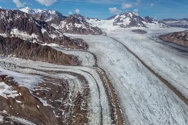
U-shaped valleys: Wide, U-shaped valleys formed by glacier erosion. Example: Valleys in the Alps.
Circus (Glacier Basin): These are bowl-shaped depressions carved by glaciers at their peaks. Example: The glaciers on Uludağ.
Moraines: These are masses of rock and soil deposited by glaciers. Example: the moraines of the Swiss Alps.
Fjords: Steep-sided, sea-filled valleys formed by glaciers eroding towards the sea. Example: Norwegian fjords.
Drumlin: A mound-shaped moraines formed during the movement of a glacier.
Esker: Long, serpentine sand/gravel banks formed during glacial melting.

Sand Dunes (Barchans): These are accumulations of sand formed by the deposition of sand by the wind. Example: Barchans of the Sahara Desert.
Wind Ridges: Long ridges formed by the erosion and deposition effects of wind. Example: Central Asian steppes.
Deflation Pit: Formed by wind eroding the surface, creating a pit. Example: Gobi Desert.
Fan and Wind Waves: These are small, inclined depositional forms formed by the accumulation of materials carried by the wind.
Wind Stone: Stones and rocks eroded by the wind.

Coastal Bay and Coastal Cape: These are coastal extensions shaped by the erosion and deposition effects of waves and currents. Example: Kapıdağ Peninsula.
Lagoon: Shallow lakes separated from the sea by sandbars formed by waves and currents. Example: Büyükçekmece Lagoon.
Coastal Barriers and Tombolos: Natural barriers formed by the accumulation of sand and stones, and narrow coastal extensions connecting the island to the mainland. Example: Tombolo areas in Bodrum.
Cliffs: Steep coastal slopes formed by wave erosion. Example: Datça Cliffs.
Lagoon Bar: Accumulation of sand or stones separating the lagoon from the sea.
Tertiary Shore Platform: Flat rock platforms formed by wave erosion.

Also known as karst landforms:
Cave: These are spaces formed by underground water dissolving rocks. Example: Damlataş Cave, Alanya.
Sinkholes: These are holes formed by the collapse of limestone or gypsum layers dissolved by groundwater. Example: Konya Sinkholes.
Sinkholes and Ponor: These are pits where groundwater flows down to the surface or drains. Example: Antalya Düden Waterfall.
Stalactites and Stalagmites: Vertical formations formed by mineral deposits in caves. Example: Karain Cave.
Karst Valley: Depression valleys formed by the dissolution of groundwater.
Agriculture and settled life flourished most in flat lands , as fertile soils and easy irrigation provided ideal conditions for early human civilizations. River valleys such as the Nile, Tigris, and Euphrates both nourished the soil and provided the water necessary for irrigation. This allowed civilizations like Egypt and Mesopotamia to produce surplus food, grow their populations, and develop complex urban and social structures. Furthermore, flat lands facilitated infrastructure and urbanization, supporting the development of civilizations.
The impact of landforms on human life influences where people choose to live and how densely distributed their populations are. Flat, fertile plains, river valleys, deltas, and volcanic areas with rich soils generally have high population densities because they are suitable for agriculture and human settlement. In contrast, mountainous areas, steep slopes, deserts, and regions with poor soil quality or harsh climates generally have low population densities due to their harsh living conditions.
Landforms directly influence routes, costs, construction feasibility, and the types of transportation systems that can be developed. Plains and plains allow for easier and cheaper efficient transportation networks such as roads, railways, and highways. Mountains, on the other hand, are restrictive and require costly engineering solutions such as tunnels, bridges, and switchbacks. Rivers, as natural waterways, facilitate transportation but require bridges or ferries. Deserts and other harsh terrains present challenges, such as extreme temperatures and variable surfaces, that make infrastructure development and maintenance difficult.
In general, transportation networks tend to follow the path of least resistance created by landforms, typically through plains, valleys, and gentle slopes, to minimize costs and improve connectivity.
Turkey's landforms have been formed as a result of the country's geological structure, tectonic movements, and natural processes. Both internal and external forces have influenced the formation of Turkey's landforms. Therefore, the fundamental characteristics of Turkey's major landforms should be evaluated along with their regional distribution.
Mountains: The North Anatolian Mountains lie to the north of Turkey, the Taurus Mountains to the south, and the Eastern Anatolian Mountains to the east. These mountains were raised by plate movements and fault lines. In this context, the influence of internal forces on the formation of Turkey's landforms is quite evident.
Plateaus: Extensive plateaus occur in Central and Eastern Anatolia. These plateaus, shaped by tectonic movements and erosion processes, constitute a significant part of Turkey's major landforms.
Plains: The Çukurova, Konya, Büyük Menderes, and Gediz Plains are notable as fertile landforms in Turkey. These plains are strategically important for agriculture and population settlement.
Coasts and Lagoons: The Aegean and Mediterranean coasts contain landforms such as deltas, lagoons, and tombolos. The Black Sea coast, with its narrow, cliff-lined structure, is an example of landforms shaped by external forces in Turkey.
Special Landforms: Sinkholes and crater lakes in Central Anatolia and karst pits in the Aegean and Mediterranean regions are notable among Turkey's landforms and features.

If you look at the physical map of Türkiye, elevation increases as you move east. This means mountains, valleys, and flood plains are more common. Deltas are more common in the Marmara, Mediterranean, and Aegean regions. In general, the most common landforms you'll encounter in Türkiye's seven regions are:
Area | Landforms |
Marmara | Delta, Barrier, Lagoon, Crater, Sinkhole |
Aegean | Delta, Lagoon, Tombolo, Karst Pits (Doline/Porch), Meander |
Mediterrenian | Delta, Lagoon, Crater, Cliff, Sinkhole |
Black Sea | Flood Plain, Cliff, Valley, Karst Pits, Embankment |
Central Anatolia | Sinkhole, Crater Lake, Flood Plain, Meander, Karst Valley |
Eastern Anatolia | Crater, Sinkhole, Valley, Flood Plain, Moraine / Drumlin |
Southeastern Anatolia | Delta, Flood Plain, Barrier, Karst Pits, Crater |
Among the maps used to represent landforms , topographic maps, physical maps, digital elevation models, geographic information system (GIS)-based maps, and satellite imagery are prominent. These maps allow for detailed visualization of mountains, valleys, plains, plateaus, and coastal systems, revealing slope and elevation differences, and facilitating understanding of the distribution of natural and artificial formations. Thanks to modern technologies, these maps not only present a static view but also allow users to examine the terrain from different perspectives through 3D modeling and interactive tools.
Today, landforms, and particularly isohypse landforms, are widely used to clearly illustrate slope and elevation differences. In Turkey, high-resolution satellite data and GIS-supported maps provide detailed depictions of the slope distribution of the Taurus Mountains, sinkholes and crater lakes in Central Anatolia, and the cliff and delta systems along the Black Sea and Aegean coasts. This allows Türkiye's landforms to be precisely analyzed and visualized for both academic research and applications such as urban planning, agriculture, and disaster management.

Different methods are used to represent landforms on maps, and each facilitates understanding the terrain. Coloring represents elevation differences through color tones; lowlands are shown in light colors and highlands in dark colors, visualizing mountains, valleys, and plateaus. Rasterization conveys the terrain's slope and surface texture through lines or hatchings, providing detailed visualization, especially in densely populated areas.
Another classic method is shading , which creates the perception of height and depth on a map through the effects of light and shadow. Relief physically elevates the map surface, creating a three-dimensional impression of landforms such as mountains, valleys, or hills. One of the most technical and widespread methods is the contour line (contour drawing) , which clearly reveals terrain details, slopes, and elevation differences through lines connecting points of the same elevation.
Today, these methods are being applied more precisely and interactively by combining them with digital elevation models and GIS-supported maps . The steep slopes of the Taurus Mountains in Turkey, the sinkholes in Central Anatolia, and the karst basins along the Aegean coast can be easily analyzed on modern maps using these methods.


Comments