


Oct 8, 2025


Oct 8, 2025


Oct 7, 2025


Oct 7, 2025


Oct 7, 2025


Oct 7, 2025

Updated: Oct 26, 2025
The digital or physical maps we use daily have always been created through calculations. Of course, calculating points on digital maps is always more practical thanks to the advancements in technology, and a standard system is used. The location where you're reading this article has a mathematical point: coordinates , or a point based on latitude and longitude. So, how difficult is finding coordinates in general? Thanks to the existing coordinate system, it's not a matter of much effort. Finding latitude and longitude is similar. The only question is learning what these systems do. Let's get started.
A coordinate system is a method used to determine the location of a point on Earth. Most coordinate systems use two numbers, a coordinate, to determine a point's location. Each number represents the distance between the point and a fixed reference point called the origin.

Coordinates are a pair of numbers used to determine the location of a point or shape on a 2-dimensional plane. We describe the location of a point on a 2-dimensional plane using two numbers called the x-coordinate and the y-coordinate.
The simplest answer to the question of how to find the coordinates of a location comes from technology itself. Open Google Maps, tap and hold anywhere on mobile, and the coordinates will appear in the search bar above. On desktop, right-click on the desired location, and the coordinates will appear as the first option.
On Yandex.Map, right-click a location on the desktop and select "What's here?" A window will open on the left, where you can find the coordinates. On mobile, tap and hold a location and select "What's here?" You'll see the "Coordinates" section at the bottom of the screen.
The physical coordinate device is also functional for determining location.
Geographic coordinate systems are based on a three-dimensional ellipsoidal or spherical surface, and locations are described using angular measurements, usually in decimal degrees. These measurements are expressed in degrees of longitude (x-coordinates) and degrees of latitude (y-coordinates). The location of the datum is expressed as positive or negative numbers: positive x and y values for north of the equator and east of the prime meridian, and negative values for south of the equator and west of the prime meridian.
To indicate the location of a point on a map, coordinates are expressed in two basic formats:
Degree, Minute, Second (DMS) Format: This is the format frequently used in traditional and map reading training. Each angle is divided into three as follows:
Degree (°)
Minute (') → 1 degree = 60 minutes
Seconds (") → 1 minute = 60 seconds
Example: Latitude: 41° 00' 29.52" N Longitude: 28° 58' 42.24" E
Decimal Degree (DD) Format: This is the most commonly used format in modern digital maps and GNSS systems. A degree is expressed as a decimal. One degree is approximately 111 km in latitude. In longitude, this value is 111 km at the equator and decreases as one approaches the poles.
Example: Latitude: 41.0082° NLongitude: 28.9784° E
Conversion Formula: Decimal Degrees = Degrees + (Minutes ÷ 60) + (Seconds ÷ 3600)
Example Conversion: 39° 55' 30" = 39 + (55 ÷ 60) + (30 ÷ 3600) = 39.925°

Lines of latitude, like imaginary circles, encircle the Earth and are designated by numbers representing the distance north or south of the Equator. Lines of longitude, on the other hand, extend from the Earth's top to its base, dividing it into sections like orange slices. Or, for an easier recall, think of latitude as width and longitude as length. Furthermore, latitudes are parallels, and longitudes are meridians.
Latitude and longitude measurements can be written in a variety of ways. For example, 211 degrees, 22 minutes, and 30 seconds is written as 211° 22´30“, or with spaces: 211 22 30; or with a decimal point after the degrees, as 211.22´30”, or with a decimal point after the minutes, as 211 22.30. One degree of latitude is approximately equal to 111 kilometers.
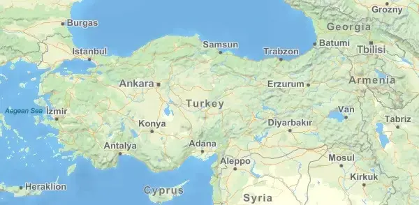
Turkey's geographic coordinates lie between 26°-45° east longitude (meridian) and 36°-42° north latitude (parallel). If we were to interpret Turkey's coordinates on Earth, it is located in the northern and eastern hemispheres.
There are many different methods and systems for finding the coordinates of a location. These systems vary depending on the measurement purpose, accuracy requirements, and the technology used. Below are the main coordinate systems commonly used in both engineering and surveying:

The Cartesian coordinate system, also known as the orthogonal coordinate system, describes the location of points using perpendicular axes that intersect at a point called the origin. The location of any point can be defined by its distance from the origin along each axis. Named after the French philosopher and mathematician René Descartes, this system is the most widely used coordinate system. It has applications in everything from photography to computer science and geography, and is fundamental to the definition of vectors and analytic geometry, allowing algebraic solutions to many geometric problems.

The polar coordinate system, also known as the polar coordinate system, is a coordinate system that uses distance and angle values to determine the location of a point. In this method, the starting point (the pole) is used as a reference point, and the point's distance from the pole is first measured, then its direction is determined using a specific angle. For example, a definition such as "10 meters away, at a 45° angle" is used. In cartography, the polar coordinate system is frequently used in location studies based on angle and distance measurements, engineering projects, and land surveying.

The UTM Coordinate System (Universal Transverse Mercator) is a projection system that divides the world into 60 distinct zones, measuring each zone on its own local plane. In this system, positions are expressed in meters rather than degrees, facilitating precise distance and area calculations. The UTM coordinate system is widely used in fields such as cartography, engineering, land surveying, GPS data processing, and geographic information systems (GIS). It provides more accurate results than geographic coordinate systems, especially over large areas, and provides a standardized positioning system on a global scale.

The three-dimensional coordinate system used to specify the location of a point using the point's radial distance, azimuth, and elevation from a given plane is known as the cylindrical coordinate system. This coordinate system is useful when working with cylindrical systems. For example, water flow through a pipe can be calculated using the cylindrical system.

The International Terrestrial Reference Frame (ITRF) is a precision global coordinate system used to determine locations on the Earth's surface. It is an implementation of the International Terrestrial Reference Frame (ITRS), which defines a geocentric coordinate system fixed to the center of mass of the entire Earth, including its oceans and atmosphere.
The system is Earth-centered and stationary, accounting for tectonic plate movements and Earth's deformation. ITRF is regularly updated with data from GPS, satellite laser measurements, and other space geodetic techniques, ensuring accuracy and compatibility across different measurement systems.

The World Geodetic System 1984 (WGS84) is a global reference system used to determine locations on the Earth's surface. WGS84 is a reference system used by satellite navigation systems such as GPS and is used in various mapping applications. WGS84 coordinates are typically given in degrees (°), minutes (′), seconds (″) , or decimal degree format.
WGS 84 coordinate example: Latitude: 41.0082° N - Longitude: 28.9784° E (Turkey geographic coordinates)


Comments