


Oct 7
Today, maps have evolved into tools that serve much greater purposes than simply providing us with direction, and they continue to evolve. We have access to countless maps for various purposes, such as mining, earthquake, fire, vegetation, or population analysis. But sometimes we need maps that illustrate multiple features. For example, we need to examine transportation networks, waterways, and fault lines. That's when GIS comes into play. If you're wondering what GIS means, you'll find it in Geographic Information Systems , or GIS in English. So, what is GIS, what does it do, and what do GIS maps look like? The answers are here.
GIS (Geographic Information Systems) is a collection of computer hardware, software, and geographic data used to capture, manage, analyze, and display all georeferenced information . With GIS, you can display many different types of data, such as streets, buildings, and vegetation, on a single map. In other words, it's a multi-layered map with no limits. Each layer has a database containing information for its own graphical feature. Because it has the characteristics of a single multi-layered map, problem-solving and analysis are always easier with GIS.
The benefits of GIS include functions such as mapping, data integration, spatial analysis, decision support, operational management, and modeling . These features enable it to offer effective solutions in a wide range of areas, from urban planning and environmental protection to logistics and disaster management. Widely used in sectors such as agriculture, telecommunications, healthcare, defense, banking, and environmental management, GIS supports scientific, commercial, and societal decision-making by transforming geographic data into actionable insights.

Of course, building a multi-layered mapping system is not easy and requires large amounts of data. To build a GIS system , data is first collected, a separate listing is created for each layer, the existing data is integrated into the system, visualization is created, and finally, a ready-to-use data map is created. More specifically, a GIS system works as follows:
Data Collection: Points, lines, polygons and their feature information are obtained from sources such as satellite images, GPS, maps, surveys and tables.
Data Storage and Management: Collected geographic data are kept in spatial databases where their features, along with location and shape information, can be stored in an organized manner.
Data Integration: Different data sets are linked based on latitude, longitude and altitude, and related analyses are performed.
Data Analysis: Operations such as querying information at a specific location, measuring proximity, examining changes over time, and modeling different scenarios are performed.
Visualization: Patterns, relationships, and geographic context in data are made understandable through maps and charts.
Decision Support: Helps make informed, location-based decisions in areas such as urban planning, natural resource management, transportation, and emergency response.
The rich and detailed images provided by remote sensing are fed into GIS databases. GIS integrates this data with field measurements, maps, and other geographic information to perform powerful analyses. This allows us to track changes over time, uncover spatial relationships, and model future scenarios.
For example, an urban planner obtains up-to-date land use maps through remote sensing , and GIS combines these maps with infrastructure projects, population data, and environmental impact analyses to enable sustainable urban planning.
For example:
Natural Resource Management: Access to up-to-date and accurate data for the efficient use of forests, watersheds and agricultural lands.
Disaster Risk Reduction: Rapid situation assessment and crisis management in natural disasters such as floods, earthquakes and fires .
Efficiency in Agriculture: Monitoring plant health, optimizing irrigation and fertilization processes.
Environmental Monitoring: Long-term tracking of habitat changes, pollution and climate change impacts.
Urban Development: Planning of new residential areas, traffic and infrastructure management.
A GIS system has five components: Hardware, Software, Data, People, and Methods. If any of these components are missing, the system will not function properly. Each is critical to the accurate and effective processing of geographic information.
Hardware | The computer on which GIS runs, web or cloud |
Software | Interface and tools for storing, analyzing and displaying information |
Data | Geographic information required to create layers |
People | The power that manages, develops and analyzes the system |
Methods | Working according to plans and business rules |
GIS plays a critical role in many areas such as urban planning , agricultural management , forest resources , landscape design , geological studies , defense operations , security services , tourism sector , archaeological research , local government activities , population data analysis , educational planning , environmental protection and health services .
GIS supports the accurate and rapid decision-making processes these sectors require through its capabilities in spatial data analysis , mapping , spatial modeling , and data visualization . GIS technology is indispensable for sustainable urban development, increased agricultural productivity, forest fire prevention, disaster management, security operations, and environmental audits.
With its applications in different sectors, GIS forms the basis of critical processes such as strategic planning , resource management and risk analysis , increasing efficiency and reducing costs in both the public and private sectors.
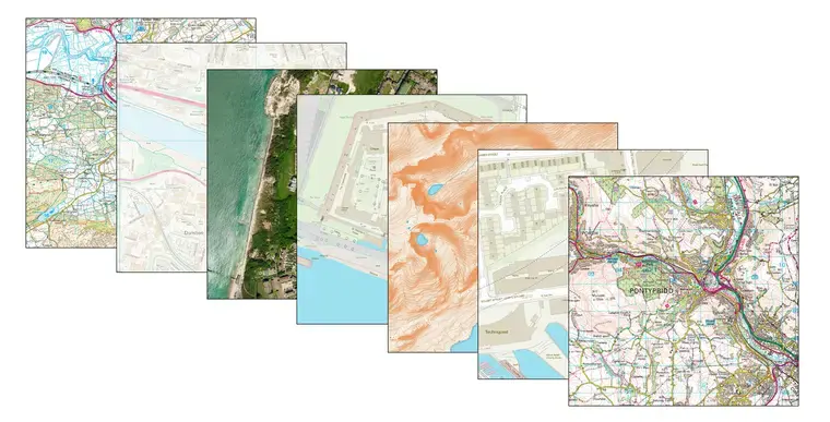
GIS maps are multilayered maps created based on the intended use of the collected data, and can be accessed via desktop, web , mobile, or cloud applications. Furthermore, the methods used with the available data also play a role in the GIS map. Generally, GIS maps have the following characteristics:
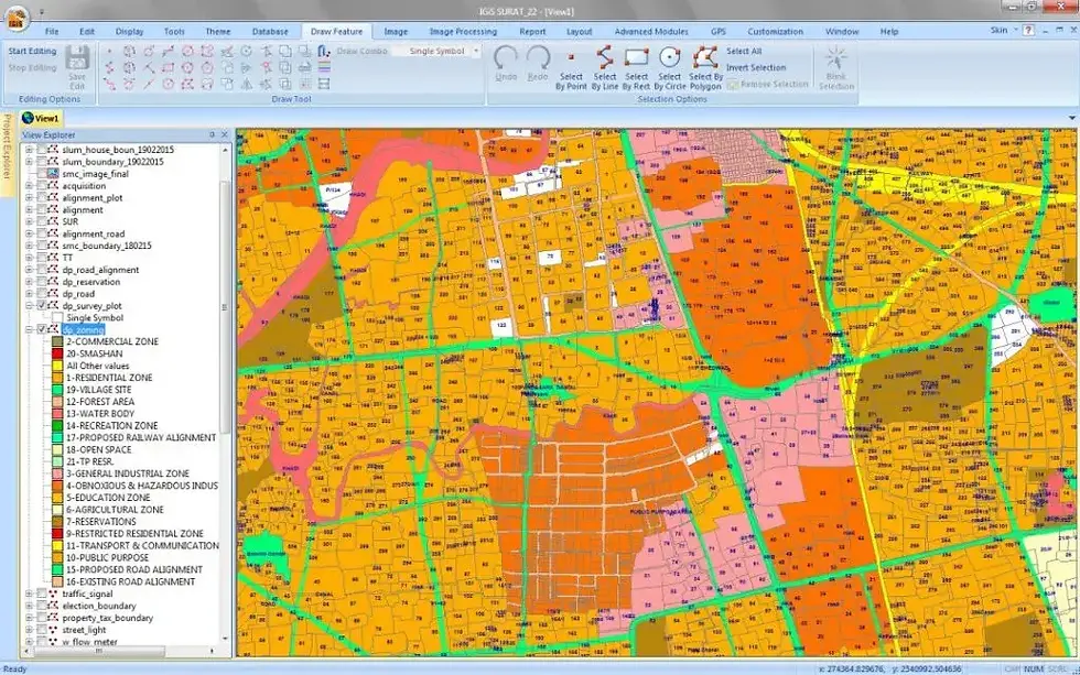
1. Layered Structure: Different types of data are stored in separate layers. For example, information such as roads, water resources, and land use are located in separate layers, and the user can turn these layers on or off as needed. This makes complex data simpler and more understandable.
2. Dynamic and Interactive : GIS maps are interactive. You can zoom in and out on the map, query information, and instantly access detailed data about specific areas.
3. Data Diversity and Integration: Integrates not only geographic data but also a wide variety of information such as demographic, economic, environmental.
4. Real-time Update: Some GIS maps can instantly display current data such as traffic status, weather conditions, and disaster information.
5. Flexibility in Scale and Detail: Data can be presented at various levels, from very large scales to very fine detail. The level of detail can be easily adjusted to suit user needs.
6. Analysis and Modeling Capability: Allows for spatial analysis. For example, complex operations such as shortest path calculation, risk analysis, and land use change modeling can be performed.
A GIS operator is someone who uses specialized geographic information systems to interpret data and create maps and models. These systems can be complex and require practice and training to master. In addition to helping those who need more familiarity with this technology use these systems and achieve the necessary results, GIS specialists can also provide IT and technical support.
The Department of Geographic Information Systems is an academic program specializing in the collection, management, analysis, and visualization of spatial data. In this program, students receive comprehensive training in mapping techniques , database management, remote sensing , GIS software (such as ArcGIS and QGIS), and geographic data analysis. For more information about the Department of Geographic Information Systems, please contact our experts for consultation. you can get.
Job opportunities in the geographic information systems department include data analysts, survey engineers, GIS specialists, and project managers in areas such as public institutions, the private sector, urban planning, environmental management, natural resources, defense, and disaster management.


Comments