


Oct 8, 2025


Oct 8, 2025


Oct 7, 2025


Oct 7, 2025


Oct 7, 2025


Oct 7, 2025

Updated: Oct 28, 2025
Creating a 3D map of the world sounds cool, right? But once you delve into it, you realize how complex and demanding the process actually is. That's where LiDAR technology comes in.
It might sound like science fiction, but it's not—LiDAR is used in many fields today, from archaeology to urban planning. So, what is LiDAR? How does a LiDAR scanner work? How can a landform be mapped so precisely with laser beams and time calculations? Without wasting any time, let's explore what a LiDAR system is.
LiDAR is a remote sensing technology that uses laser beams to precisely measure distances and movements in an environment in real time. The laser transmitter in the system sends short pulses of light to a target, which bounce back and forth. The receiver detects the reflected light and measures the time of travel (TOF). Multiplying this time by the speed of light gives the distance, which reveals the distance of each distant point.

A LiDAR sensor is the physical hardware that implements the technology. A LiDAR scanner consists of a laser emitter, receiver, scanning mechanism, and often auxiliary components such as a GPS or IMU. The sensor directs laser light at the target, detects the reflected reflection, and generates raw data. This raw data is then processed into maps, models, or measurements. While LiDAR is the general name for a technology, a LiDAR sensor is the device that embodies that technology and is used in the field.
LiDAR stands for Light Detection and Ranging. Its Turkish equivalent is Light Detection and Ranging. The technology's name is often used as a brand in its own right. Therefore, many sources refer to it directly as LiDAR without specifying its acronym.

LiDAR systems typically consist of three main components: a laser scanner, a GPS/IMU (localization and orientation unit), and a data recording system. In scans conducted from platforms such as aircraft, drones, or tripods, the GPS determines the location of the LiDAR source, while the IMU corrects the device's orientation angles, such as roll and roll. Ultimately, each laser point is placed in a global coordinate system, creating a fully 3D point cloud of the surface. This point cloud is comprised of the location information from millions of laser returns that form the cloud trace.

Scanning can be accomplished using various methods. For example, there are LiDARs that scan a 360° area using rotating mirrors, or solid-state LiDARs that perform single-point, vertical-axis scanning using MEMS mirrors. Many automotive LiDARs scan the environment by rotating multiple laser beams millions of times per second. There are even atmospheric LiDARs that operate at different wavelengths for airborne particles; these are used to measure humidity or aerosols. However, typical LiDARs for mapping use low-power lasers in the infrared wavelength (900–1550 nm), which is invisible to the human eye. Reflective surfaces range from solid materials (buildings, asphalt) to water molecules; sometimes, multiple reflections can even reach the ground beneath vegetation.
One of LiDAR's most surprising features is its ability to measure extremely precisely . In theory, measuring the time of flight of laser pulses with millimeter accuracy is possible. However, in practice, many factors play a role. For example, the error in measuring the time of a LiDAR pulse, combined with errors in the platform's position and orientation, can often lead to errors on the order of centimeters. For example, in LiDAR on a moving vehicle or drone, the accuracy of GNSS/IMU sensors can leave an error of only a few centimeters on average.
To reduce these errors, some methods are applied: Device calibrations and coordinate alignments (boresight and strip alignment) are performed. Flight plans are created with overlapping scan strips (strip overlap) , thus increasing repeatability by measuring the same point in multiple passes. In static scans, stabilizing the laser source and selecting a tripod reduce errors. Furthermore, when combined with photographic methods (e.g., combined LiDAR + photogrammetry ), accuracy increases significantly through joint data optimization.
The distinction between LiDAR precision and accuracy is also important. Low deviation in repeatable measurements means high precision, while measurement close to the true distance means high accuracy. Using high-quality GNSS , RTK corrections, frequent control points, and advanced IMUs can improve absolute accuracy to millimeters. In one study, a hybrid method combining satellite LiDAR scans and aerial photography improved the 3D location of thousands of points to millimeter precision—proving the powerful results LiDAR and photogrammetry can deliver together.
As we can see from this, a dense point cloud is also crucial for LiDAR data. High beam density captures surface details more sharply, while multiple simultaneous returns allow for measurement of the lower level in agricultural or forested areas. Low-altitude flights or multiple scan lines increase data density, allowing for the clearest identification of topographic slopes, building edges, and infrastructure features. Furthermore, systems that record full-waveform LiDAR waves can analyze the returned signal waveform to provide more precise distance measurements.
LiDAR technology is used in mapping and GIS , autonomous vehicles and transportation, forest and agricultural management, geology, archaeology, urban planning, and air and space applications. Its high precision allows experts to make more informed decisions.
LiDAR is an indispensable tool in modern mapping and Geographic Information Systems (GIS). Land surfaces, buildings, and infrastructure can be modeled in 3D with high accuracy. For example, in the US, the USGS uses LiDAR data to create a national terrain model and flood risk maps. Data obtained from point clouds is used in a wide range of studies, from topographic analysis to land use planning. This enables data-driven decisions for cities, agricultural lands, and natural resource management.

iDAR creates a 360° real-time map of the vehicle's surroundings. Even in the dark, it can detect pedestrians, cyclists, or road signs from hundreds of meters away. For example, Waymo's driverless vehicles use LiDAR data to detect surrounding objects at high resolution around the clock. According to Waymo , LiDAR sensors play a key role in autonomous driving, with their ability to see objects from hundreds of meters away . LiDAR is a key data source for improving safety in robot taxis and advanced driver assistance systems (ADAS).
Scanning terrain under dense vegetation is LiDAR's strength. A point cloud obtained by drone LiDAR in a forested area near Barnsley, England, enabled measurements such as tree height and density. This enabled detailed analyses of forest health, disease detection, carbon stocks, and fire risk. Automated LiDAR scans can be used in a variety of areas, from calculating growth rates for management plans to determining irrigation or pruning strategies. On a more global scale, LiDAR datasets are also being used to simulate forest fires in advance and estimate biome mass.
In agriculture, LiDAR creates detailed slope maps of fields. Drone-mounted LiDAR models the field surface and cultivated plants in 3D, analyzes plant height, and optimizes irrigation. High-accuracy LiDAR data can be used to predict water accumulation due to land slope or to identify drought stress. Drought simulations can be built on this data for efficient water use. Furthermore, in sensitive agricultural areas such as vineyards and orchards, LiDAR-derived plant models can be used to monitor plant development stages.

In geology, LiDAR enables detailed examination of fault lines, canyons, valleys, and landslide zones. For example, earthquake risk studies in California use LiDAR data to create 3D models of fault lines to identify potential hazard zones. Furthermore, volcanic areas and rocky terrain can be mapped with unprecedented detail thanks to LiDAR. This technology accelerates understanding of geological processes and helps predict disaster risks more confidently.
LiDAR plays a significant role in research uncovering lost civilizations. For example, LiDAR scans conducted around the ancient city of Tikal in Guatemala revealed 110,000 structures beneath the trees. Furthermore, 30% of the structures were comprised of vaulted church-style architecture hidden from view. This data was used to analyze the social structure of ancient Mayan society. LiDAR has become a primary tool for uncovering hidden pathways, agricultural terraces, and burial chambers in dense forests. For example, similar LiDAR studies in the Caribbean revealed the Mayan city of Caracol beneath six centuries of rainforest cover. Archaeologists say, "LiDAR provides a fascinating amount of information," emphasizing the technology's contribution to historical scholarship.
LiDAR is revolutionizing urban planning. For example, the City of Nottingham, UK, flew a flight with a Leica CityMapper-2 sensor to create a digital twin of its entire city. This hybrid system captured both LiDAR and imagery data, producing detailed models of buildings and surfaces at better than 5cm resolution in a single flight . The resulting 3D city model is used for processes such as new road construction, infrastructure changes, or public engagement. This allows the digital twin to test "what-if" scenarios, from new bike paths and building projects to traffic flow. More broadly, smart city initiatives are applying LiDAR data to a wide range of applications, from infrastructure monitoring to traffic management.
LiDAR can be used on a variety of aerial platforms, from drones to helicopters and satellites. It provides detailed surface data for wide-area surveys, especially in hard-to-reach areas. For example, NASA's IceBridge project uses LiDAR to measure the thickness of Antarctic and Greenland glaciers, contributing to climate change research. Satellite-based LiDAR enables global monitoring of forests, water bodies, and urban areas.
The future of LiDAR technology is bright as sensors are being developed with smaller, cheaper, and solid -state designs. Even new quantum sensors are being researched. Their applications are expanding, from autonomous vehicles to phones and robot vacuum cleaners.
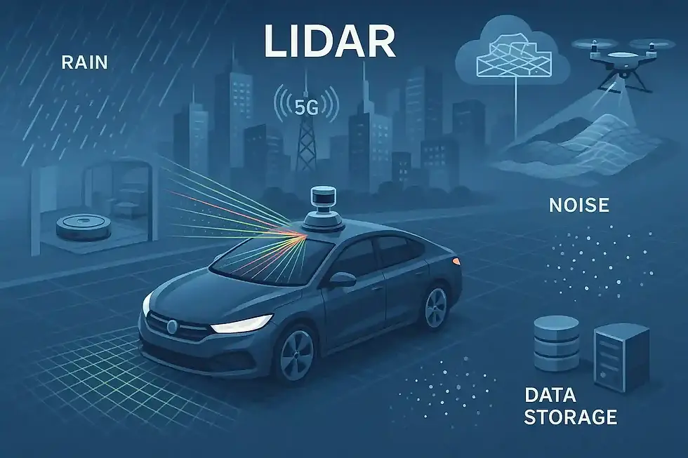
LiDAR integrated with real-time data will enable a wide range of applications, from traffic simulations to infrastructure maintenance. Thanks to computing power and artificial intelligence, massive point clouds can now be processed by automated algorithms into meaningful models. Cloud data carried via 5G/6G connectivity enables the development of real-time, end-to-end mapping systems.
However, there are challenges to using LiDAR. Cost can still be a barrier, as multi-channel, high-resolution LiDARs are quite expensive. Furthermore, the need for extensive data collection necessitates significant data storage and processing power. Data processing requires rigorous engineering for steps like noise removal and strip alignment. LiDAR is also sensitive to weather conditions : Heavy rain, fog, or snow can disrupt the propagation and return of laser pulses. Detection can be impaired on light-colored or highly absorbent surfaces. Even complex scans within buildings, such as those in narrow spaces, can require complex modeling due to reflected signals.


Comments