
Differences Between Political and Physical Maps
- Hakan GÜNGÖR
- Oct 7, 2025
- 3 min read
Maps are visual and scientific tools that help us understand the Earth's surface. However, not all maps provide the same information. Different types of maps have been developed depending on their intended use, and two of the most common are physical maps and political maps .
These two types of maps differ not only visually, but also fundamentally in terms of the type of information they provide, the areas they are used in, and their data content. In this article, we detail what physical and political maps are, what they serve, and how they differ, with examples.
What is the Difference Between a Physical Map and a Political Map?
Physical Map | Political Map |
Shows natural structures such as mountains, plains, rivers, lakes | Shows administrative boundaries and settlements |
Colors determine elevation and landforms | Colours are symbolic to distinguish regions. |
Give topographic details and show isohypse curves | Shows boundary lines and symbols |
Used for nature analysis and land use | Used for education, politics and population studies |
Shows terrain-based details | Shows administrative level details |
What is a Physical Map?
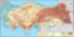
Physical maps depict natural landforms. Natural features such as mountains, valleys, plains, lakes, rivers, and plateaus are prominent in these maps. They provide detailed topographic information and may also include isohypses (contour lines) for measurement and analysis. They are used in geography and geology studies, nature tourism, land planning and pre-construction analysis, and disaster risk assessment.
Physical maps also feature color gradients based on elevation. The meaning of physical map colors:
Green : Lowlands (plains)
Yellow and orange : Medium height
Brown : High mountain regions
White : Snow or glacier areas
What is a Political Map?

Political maps are maps depicting human-made administrative and political boundaries. These maps highlight administrative regions such as countries, cities, provinces, and districts. Each country or region is shown in a different color. Populations (cities, towns) are marked with symbols. Transportation infrastructure such as roads, ports, and airports are also visible.
It is used in education, administrative planning and border resolution, population distribution, socioeconomic analysis and diplomacy.
Points to Consider When Selecting a Map
When choosing a map, it is necessary to first determine the purpose:
If you are going to analyze the natural environment, you should choose a physical map.
If you want to understand the borders, cities and settlements, the political map will be more helpful.
Some digital maps present these two types as layered structures, allowing the user to turn layers on and off as needed. For example:
Cartographero's GeoPDF maps can include both physical and political details.
Both geographic and administrative layers can be used together on Google Maps .
Physical and Political Maps in Modern Cartography
Today, maps are no longer just paper; they have evolved into digital, interactive, and location-based tools. With the advancement of cartography:
Physical maps are now created from satellite imagery or with LiDAR technology .
It can be integrated with political maps, population data, statistical distributions and real-time data.
Ultimately, physical and political maps provide different types of data, making the information users need more understandable. A physical map is preferred for understanding the location of a landform , while a political map is preferred for determining which country or administrative border the area falls within. Using the right map for the right purpose is key to accessing information more quickly and accurately.


